Thresholds in East Asian marginal seas circulation due to deglacial sea level rise

Introduction
Extraordinary rise of sea level is a most challenging climatic effect, as a consequence of the on-going global warming1,2,3. According to paleoceanographic evidences, sea level was even higher than the modern condition by a few meters during the last interglacial (~ 130–115 ka BP), as a heritage of naturally deglacial sea level rise4,5. On the glacial-interglacial time scales, the global ocean has tempered the effect of sea level oscillations by over 100 m4, in particular for the marginal seas via the processes of land-sea evolution. This is a typical circumstance for the development of circulation in the East Asian marginal seas (EAMS, one of globally largest marginal-sea region) since the last deglaciation (Fig. 1 and Supplementary fig. 1). Although studies have linked the deglacial evolution in the EAMS circulation to the coeval climatic processes of e.g., Asian Monsoons6,7,8 and the Kuroshio Current system9,10,11, the impact of changing bathymetry and the corresponding land-sea masks on the circulation remains unresolved. In this study, we hypothesize the existence of abrupt-change points in the relationship between sea levels and the EAMS circulation, leading to nonlinear evolution in the EAMS circulation from the last deglaciation to the present, based on modelling simulations and intercomparison with existing paleoceanographic evidences. Note that here we only test how the changes in sea level and the associated opening of certain key straits would affect the EASM, thus we applied fixed present-day surface and lateral boundary conditions.

a, b The global and regional views of the coastal lines and bathymetries in the EAMS, respectively. c The bathymetries in the Soya Strait region.
Results and Discussion
Modelled EAMS circulations based on different sea levels
Our modelling results show abrupt change in the EAMS circulation two times: when sea level rises beyond −40 and −5 m (Fig. 2a–d). Once the sea level becomes higher than −40 m, the Soya Strait opens as an oceanic gateway, and triggers the formation of the so-called ‘Taiwan-Tsushima-Tsugaru & Soya’ (3T-S) circulation system in the modern ocean12,13 (Fig. 1c and Supplementary figs. 2, 3). Specifically, on the basis of the open Soya Strait and the established 3T-S circulation system, the Kuroshio Current water also enters the EAMS via the Taiwan Strait besides via the deep-ocean channel east of Taiwan Island. Then, the Taiwan-Strait throughflow continuously extends northward in the EAMS and reaches the TKS, activating a TKS throughflow into the Sea of Japan. In the meantime, the water export from the Sea of Japan to the North Pacific Ocean via the Tsugaru Strait is also initialized. Therefore, our modelling results suggest that the sea level rise across −40 m exists as an abrupt-change point in the relationship between sea level rise and the EAMS circulation evolution since the last deglacition by opening the Soya Strait in a classic ‘ocean-gateway effect’14.

In sequence, (a–d) show the modelled intensities of the throughflows via the Taiwan Strait, TKS, Tsugaru Strait and Soya Strait (coloured curves and the grey shadows for their annual mean state and the corresponding seasonality), as well as the corresponding strait transect area that is scaled to the modern value (black curve), based on different sea levels between −90 and 0 m. e Relative Sea Levels (RSL) of the present22. f Relative abundance of radiolarian indicator for TKS throughflow (this study). g Past temperatures reconstruction17 as an indicator for the presence of KLM-like circulation, with lower values for the absence of KLM-like circulation. h A composite δ18O record33 for Asian Summer Monsoon (in orange) and a grain size index (GSI) record34 for Asian Winter Monsoon (in green). i The relative abundances of radiolarian indicator for TKS throughflow against the corresponding sea level rise from −90 to 0 m of during 14 to 0 ka, with ACP meaning ‘Abrupt-Change Point’.
Along further sea level rise from −40 to 0 m, the EAMS circulation becomes stronger generally in an almost continuous manner (Fig. 2a–d). Here, this constitutes an invigoration process in the EAMS circulation, linked to the widening and deepening of the Taiwan Strait along the sea level rise. It thus results in the development of the Taiwan-Strait throughflow and also its downstream including the throughflows via the TKS, Tsugaru Strait and Soya Strait, in the form of an intensifying ‘ocean-gateway effect’ at the Taiwan Strait (Fig. 2a).
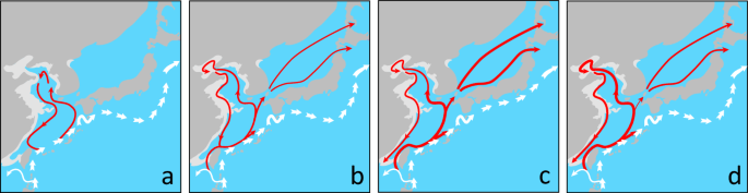
Notably, the overflows between the Sea of Japan and the North Pacific Ocean, including the throughflows via the TKS, Tsugaru Strait and Soya Strait, commonly exhibit a prominent, surprising overshoot towards the end of our simulated deglacial sea level rise, at around −5 m sea level (Figs. 2 and 3). According to our modelling results, a replacement of the Kuroshio Large-Meander15,16 like (KLM-like) circulation to a relatively straighter current along the southeastern coast of Japan (Fig. 3). Such shift from KLM-like flow to the along-shore current virtually occured as an acceleration in the along-shore current at the southern coast of Japan. Following the around-island integral constraint within the ‘Island rule’ theory17,18 with respect to the Islands of Japan, the TKS throughflow at the coast of the other side, i.e., the northern side, thus intensified, as the response (Fig. 3 and Supplementary fig. 5). Here, our modelling results are also in line with paleoceanographic evidence for the onset of an overshoot in the TKS throughflow at about −5 m sea level19 (Fig. 2g). Overall, at around −5 m sea level, on top of the continuously growing ‘ocean-gateway effect’ with deglacial sea level rise from −40 to 0 m, the transient appearance of the around-island integral constraint triggers the temporary overshoot in the TKS throughflow into the Sea of Japan. Likewise, because of the necessity to maintain mass-balance, the outflows via the Tsugaru Strait and Soya Strait from the Sea of Japan to the North Pacific also present an overshoot (Fig. 2b–d). This process thereby constitutes a maximum in circulation intensity through the EAMS within the Holocene.

(a, b) are the results in the experiment for 0 and −5 m sea levels, respectively. As shown, the KLM-like circulation becomes absent in (b).
Importantly, in the modelling experiment of −5 m sea level, the along-shore current in the Pacific south to the Japan Islands is characterised by a quasi-stationary field of eddies with dual cores (Fig. 3). This is distinct from the prevailing condition of a triple-core, quasi-stationary eddy field, coherent with the KLM-like circulation in the simulations with sea levels between -90 and 0 m. Based on similar variability in the modern ocean circulation, albeit on shorter time scales, previous physical oceanographic studies16,20 have assigned such changes in the western North Pacific quasi-stationary eddy configuration as a cause for the shift from the KLM to the along-shore current setting. Here, our modelling results, in line with paleoceanographic reconstructions19, provide evidence for the hypothesis that a −5 m sea level with a corresponding land-sea mask enables the condition for the existence of quasi-stationary eddies with dual cores, in tandem with the presence of a linear, along-shore Kuroshio Current system at the southern coast of Japan. Then, the actually acclerated along-shore current at the southern coast of Japan leads to the occurrence of overshoot intensity in the TKS throughflow, following the around-island integral constraint.
Intercomparison with Paleoceanographic evidences
On the basis of radiolarian species assembleges from a core near the Tsushima-Korea Strait (TKS) in the southern Sea of Japan, a recent study21 illustrates that the TKS throughflow started to increase from near-absence after 10 ka BP, before it decreases again from 7 to 0 ka BP (Fig. 2f and Supplementary fig. 7). Once transferred to sea level development between 14 and 0 ka BP22, this indicates an initiation of the TKS throughflow since sea levels higher than −40 m, and a continuous strengthening along sea level rise from −40 to −5 m, followed by a weakening from −5 m sea level to the present (Fig. 2i). This timeline of development hence supports our modelling results and inferences about the nonlinear response of the TKS throughflow to sea level rise (Fig. 2b).
Moreover, our modelling results are broadly consistent with other paleoceanographic evidence. In the southern EAMS, multi-proxy reconstructions have used to suggest a rapid development of maximum circulation intensification north of the Taiwan Island after the early Holocene23. According to our results, this pattern can be attributed to rapid establishment of the Taiwan Strait throughflow, as a part of the modern-shape 3T-S circulation system (Fig. 2). In addition, a compilation of phytoplankton biomarker contents indicates stronger impact of the Kuroshio Current water on the central EAMS in the Middle Holocene24,25, while evidence based on diatom assemblage counts also suggest the arrival of more Kuroshio Current water in the TKS area after the early Holocene26. Together, these paleocenographic evidences corroborate our modelling results about the initiation process of the 3T-S circulation system that transports more Kuroshio Current water via the Taiwan Strait into the EAMS, as a result of sea level rise from −40 to −5 m. Moreover, the alkenone evidence for the weakening in the Tsugaru-Strait throughflow from 7 to 0 ka BP27 is also in line with our modelling results about the deceleration from an overshoot in the Tsugaru-Strait throughflow along sea level rise from −5 to 0 m (Fig. 2).
Our results provide an explaination to the mystery that the initial intrusion of the TKS throughflow into the Sea of Japan was continuously established since the early Holocene, despite the TKS being open already under glacial sea level low-stand conditions28,29,30,31,32 (Fig. 2b). Here, we propose the opening of the Soya Strait to act as the necessary and critical control to ultimately develop the TKS throughflow into the Sea of Japan, as a process in the establishment course of the 3T-S circulation system once sea level rise exceeds −40 m during the last deglaciation. We thus provide an alternative hypothesis to the existing narrative that regional effects of irregular gateway shape (Fig. 2b) at the TKS affect the change in the TKS throughflow29,30. In essence, our mechanism provides an unifying explanation for the coexistence of the lake-like conditions28,31 in the Sea of Japan with an open TKS under maximal glacials.
Moreover, according to paleclimate evidences, the aburpt weakening of the TKS throughflow when sea level rise exceeded −5 m at 7 ka BP is also synchronous with a weakening in Asian summer33 and strengthing in winter monsoon34 (Fig. 2h). Within the atmosphere-ocean coupled system, the summer and winter change in the Asian monsoons commonly act to decelerate the TKS throughflow, by inducing anomulous southward wind-driven effect over the EAMS. Similarly, although on centennial scale, a weakening in the TKS throughflow at 7 and 4 ka BP also coincides with the resembled change in the Asian monsoon system (Fig. 2h). Here, our modeling results thus argue that the sea level rise exceeding −5 m acts as a control, extra to the contribution by Asian monsoons, in triggering the weakening the TKS throughflow at 7 ka BP.
Our modelling results have important implications for paleoceanographic studies, as proxies recording seasonal features may be biased in reconstructing the EAMS circulation since the last deglaciation. According to our modelling experiments, seasonality in the throughflows via the Taiwan Strait, TKS, Tsugaru Strait and Soya Strait is commonly developed synchronous with the establishment of their climatology mean states. Generally, it also presents continuous intensification coherent with the growth in the climatology mean strength along with sea level rise (Fig. 2a–d and Supplementary fig. 6). Here, we attribute the stronger seasonality in the EAMS circulation to the growing Taiwan-Strait throughflow that carries more Kuroshio Current waters of high seasonal variability35,36 into the EAMS. As a consequence, the larger seasonal offsets relative to the annual mean state may result in higher uncertainties to interpolate marine proxy results in corporating climate seasonality signals. We note that our modelling simulations with different sea levels have been carried out with identical atmospheric and ocean boundary forcings, thus in term of diagnose about stand-alone effect of sea levels on the EAMS circulation. As a result, the glacial-interglacial change of Asian monsoons37,38 and tropical Pacific ocean circulation39 through time may induce further complexity to the seasonality in the EAMS circulation.
Our findings suggest that the existence of two types thresholds via ‘ocean-gateway effect’ and ‘around-island integral constraint’ in triggering rapid shift of the EAMS circulation due to sea level rise since the last deglacition. In sequence, they may explain the nonlinear change in the EAMS circulation at −40 and −5 m sea level, respectively (Fig. 4). Developing from previous estimations28,40,41 about a linkage between the EAMS circulation and sea level rise during the last deglaciation, our results suggested −40 and −5 m as the sea-level thresholds in stepwisely shaping the modern EAMS circulation42. In particular, we develop the concept that the around-island integral constraint functions as a physically-based bridge that introduces a nonlinear shift in open-ocean circulation to induce abrupt variations of throughflow in the marginal seas. This is alternative to classic assignments about the ‘ocean-gateway effect’14 and the shift in atmospheric circulation due to the corresponding ice sheet variation along with sea level oscillation, in the relationship between sea levels and the global ocean circulation on glacial-interglacial time scales.
(a−d) Show the conditions for the RSL lower than −40 m, RSL between −40 and −5 m, RSL at −5 m and RSL of 0 m, respectively. The dark and light greys indicate the modern land and its difference compared to −40 m sea level, in sequence. A thicker line is used to indicate a stronger ocean flow.
According to our findings, there are likely exitence of more abrupt change points in the relationship between sea level and EAMS circulation due to ocean dynamics, besides well recognized ocean-gateway effect, when analyzing consequence of the ongoing sea level rise1,2. Moreover, this suggest potential occurrence of natural hazard induced by abrupt change of the circulation in global marginal seas along the ongoing and future sea level rise. To fully understand the sensitivity of sea levels and the global marginal seas circulation, it would be desirable to use a high-resolution Earth System Model in combination with the global warming climate forcings.
Methods
We simulated the EAMS circulation based on sea levels from −90 to 0 m of the present, using a high-resolution Regional Ocean Modeling System (ROMS) model43,44. The model has a horizontal resolution of 1/18° x 1/18° and 50 uneven vertical layers, and ultilizes parameterization schemes as in Yu et al.45,46, the Mellor–Yamada level-2.5 scheme47 for vertical mixing and Smagorinsky scheme48 for horizontal diffusion. The version of ROMS has been applied to simulate the modern North Pacific Ocean and EAMS, and the modelled circulation is comparable to instrumental oceanographic data45,46. In total, 11 experiments were conducted for the western North Pacific Ocean and the EAMS (Fig. 2a–d and Supplementary figs. 2, 3), with background sea levels incrementally increasing by 10 m from −90 m to 0 m, as well as a subsequent experiment for −5 m sea level to better resolve more recent Holocene changes. In addition, the climatologically averaged monthly Coordinated Ocean-ice Reference Experiments II (COREII) data49 were used as atmospheric forcing, while the climatologically averaged Simple Ocean Data Assimilation (SODA) data50 served as both initial and boundary ocean conditions across all eleven experiments. Here, among experiments with varied sea levels, our application of the identical atmospheric and ocean lateral boundaries is to highlight the diagnose about stand-alone impact of deglacial sea levels on the EAMS regional ocean circulation. By applying realistic surface and lateral boundary conditions, the conclusion reached here may change due to the interactions between the air and sea, and the changes in ocean properties associated with the addition of ice sheet melt water into the ocean. Therefore, to draw more affirmative conclusions, additional experiments using consistent surface and lateral boundary conditions are needed. Each run was integrated by 10 model years to allow for the surface oceans to adjust to different sea levels. In the last five model years the simulated EAMS circulations were checked for the development of their quasi-equilibrium states regarding the structure and intensities, respectively (see Supplementary fig. 4).


Responses