Major data gaps and recommendations in monitoring regulations of activities in EU marine protected areas

Introduction
Many activities impact marine ecosystems in European Union (EU) seas. The scale of impactful activities has been increasing1,2, while marine ecosystems have continuously degraded3,4,5. The interest in quantifying and reducing their negative impacts has also increased, as regularly illustrated with policies and research to address these pressures, notably from fishing, shipping, tourism, mineral extraction (including recently in deep-seas6), land-based activities (to tackle pollution from nutrients or plastic), or dredging2,7,8,9,10.
At sea, human activities are regulated through multi-layered policies and organizations at multiple scales, from international conventions for shipping routes to local laws and authorities for sewage plants. The Marine Spatial Planning approach (MSP) was developed to map and analyze interacting uses of the seas. In the EU, the MSP Directive “establishes a framework for maritime spatial planning aimed at promoting the sustainable growth of maritime economies, the sustainable development of marine areas and the sustainable use of marine resources” (Art. 1.1). It allows to monitor uses within national waters and coordinate actions at the EU level11. National MSPs should have been published after public consultation in 2021: as of early 2024, three were still in the process of adoption (according to the EU MSP platform webpage12). Moreover, the Directive advocates for an ecosystem-based approach13, and, together with other national and EU policy frameworks (i.e., the Habitats, Birds and Marine Strategy Framework Directives), MSPs encompass Marine Protected Areas (MPAs) which aim to preserve and restore marine ecosystems, by limiting human activities and their impacts. MPAs in the EU cover about 12% of EU seas and are designated under national law, European directives (so-called Natura 2000 MPAs, designated under the Habitats and Birds directives), and sea regional conventions, including the Barcelona, OSPAR, and HELCOM conventions14. Most EU MPAs are located in inshore and populated areas (between 0 and 12 nautical miles, in territorial waters), but most of the MPA area is located offshore14, where many activities are likely to occur.
The development of maritime activities, their planning as part of the MSP implementation, and their regulations in and outside MPAs are criticized for insufficiently addressing conservation goals and marine ecosystems’ degradation15,16,17. The few existing assessments showed little regulation or low protection levels throughout EU MPA area18,19,20,21,22,23. However, these assessments either focused solely on fisheries24,25 or used indicators of protection without detailing how the different activities are regulated by MPAs.
Indeed, accessing and assessing regulations of most maritime activities remains a challenge in EU seas, as there are limited institutionalized data collection and standardized databases compiling regulations of activities26. There are many sources of data spread across different platforms (sectoral databases, at European, national scales, in different data formats), managed by different actors, and containing information of various legal nature (e.g., laws, management plans, rulings). Much of this information has yet to be translated into standardized indicators that capture legal reality and incorporated into existing spatialized databases. In addition, these different data are accessible and understood by a limited range of actors (e.g., legal professionals, policy- and decision-makers from various sectors, MPA managers, ecology and law scientists, and data experts) with limited connections between communities, and limited sharing of their knowledge, practices, and tools27,28,29,30,31. Currently, the largest EU-wide data collection schemes separately map activities (MSP geoportals, the EMODnet platform32), and MPAs (Natura 2000 network database, gathering reports from Member States on threats to protected features). Both feature limited and unstandardized data on activities and regulations33,34. Despite ongoing initiatives aiming at connecting and standardizing these data sources and knowledge at EU, regional, or global scales (see for example the MPAtlas35, World Database of Protected Areas36, EU and international working groups developing data standards and infrastructures35,36,37,38), many of the questions on legal indicators about activities and their impacts remain too little addressed.
There is however an urge in making the regulations and associated knowledge more accessible and actionable for policy making. Indeed the use of EU MPAs to restrict activities is now part of EU policies, following the European Commission’s EU Biodiversity Strategy and the EU Action Plan to protect and restore marine ecosystems, respectively targeting 10% of strict protection per sea region by 2030 and calling on Member States to progressively ban mobile bottom fishing gears from EU MPAs39,40. These two non-legally binding policies, together with the recently passed Nature Restoration Law that aims at restoring 30% of all types of ecosystems to good condition by 203041, emphasize the interest of the Commission in reducing impacts in sensitive ecosystems. They also underscore conflicts with national authorities and stakeholders to do so42. These policies can be implemented by Member States and will require additional monitoring, given the current existing databases and data collection schemes. As a first step to improve data collection and to inform ongoing policy-making about EU MPAs, we 1) analyzed the data availability of publicly accessible databases. We used the MPA-focused database ProtectedSeas Navigator43, and because numerous EU MPAs do not have management plans in place17,44,45, we compiled a second dataset gathering multiple activity-focused databases (including all the nationally reported MSPs, EMODnet data, and more). From these databases and expert-based assessments available, we then 2) mapped regulations of activities in EU MPAs (i.e., what activities and levels of restriction).
Methods
A detailed description of the data primary sources, computation of the MPA list, formatting and filtering of data, as well as detailed standardization of regulations, is provided in the accompanying data article, publishing and describing the database (Aminian-Biquet et al.46).
MPA list and polygons
We used the MPA polygons reported in the 2023 European Environment Agency database, compiling MPAs from Natura 2000, National designations and Regional Conventions frameworks, designated up to January 2022 and located in EU national waters (this dataset does not include MPAs in the extended continental shelf, accessed in February 202347). We filtered all MPA and activity data with the marine area polygons reported under the Marine Strategy Framework Directive48 to extract their marine area. We merged fully-overlapping MPAs together. We identified MPA zoning with different regulations based on polygons reported in the MAPAMED database (containing polygons for all Mediterranean MPAs, including their zoning scheme49), the ProtectedSeas Navigator43, Roessger et al.19 in OSPAR MPAs, and Horta e Costa et al. (update from the 2019 publication21). It resulted in 4,858 MPAs and 504 zones (Fig. 1).

Protocol description presenting the formatting process of MPA polygons, data description of the three datasets, and the formatting per activity within (for PS and MSP+; expert-based assessments were already formatted per activity) and across datasets. For more details see Fig. S1 and Aminian-Biquet et al.46 particularly for the protocol to combine divergent information from the various sources.
Datasets about activities planning and regulations
We extensively searched for databases including downloadable data on EU MPA regulations, by searching for keywords (“MPA”, “regulations”, “database”, “MSP”) at EU, regional, and national scales, on the websites of EU, Sea Regional Conventions and national environmental authorities. We reached out to environmental authorities when no downloadable data was found (see Aminian-Biquet46). Table S1 presents the main databases found (MPA- or MSP-centered databases, and other national platforms). Most MPA-centered databases (e.g., WDPA) showed very limited information on regulations. We could not find any national platforms reporting specifically on MPA regulations for eight of the 22 Member States (see details in Table S1). From the databases listed in Table S1, information from MPA-focused databases (Natura 2000, national databases) was already gathered in the ProtectedSeas dataset (Fig. 1), and for MSP-like and expert-based assessments, we only included the most up-to-date and downloadable geospatial data. Data fitting these criteria were gathered in the three datasets presented below (Fig. 1)
The “MSP+” dataset gathered databases centered on reporting activities (independently from MPAs) occurring at sea (gathered between April 2022 to September 2022, only including data downloadable as geospatial data from the activity-focused databases listed in Table S1). MSP+ included data from EMODnet, national MSP geoportals, and regional databases32,50,51. Though we searched for complementary databases, MSP geoportals and EMODnet provided the largest share (>90%) of the dataset. Data were formatted as polygons, points, and lines. Polygons were filtered based on overlap with MPAs (2,164 MPAs): an activity was considered as allowed in an MPA if polygons reporting its authorization covered at least 10% of the MPA, polygons had to cover at least 90% for a prohibition to be considered (see Aminian-Biquet, et al.46). For each activity, when there was no information at MPA level but there was information from one of its zones (if any), the zone data was used for the whole MPA, if the zone covered sufficiently of the MPA area (>10% for authorizations and restrictions, and >90% for prohibitions).
The “PS” dataset gathered regulations identified from MPA management plans (or equivalent document gathering regulations, e.g., designation decrees), formatted in the ProtectedSeas Navigator database (last updated in 2021 and including data for 3312 MPAs43). Of all the MPA-focused databases listed in Table S1, we only included the ProtectedSeas dataset (“PS”), as it is expected to be the most comprehensive and standardized. We did not include databases like those of HELCOM or Natura 2000, because PS was the most updated and they should contain the same type of information, but in comparison, the Natura 2000 database only contained measures for a quarter of these MPAs. Although the initial aim of the PS dataset focused on fisheries management measures, the ProtectedSeas team also gathered data on mining, dredging/dumping, recreational and anchoring uses, but the dataset did not include data for infrastructure, transport, aquaculture, and land-based uses.
Two additional expert-based assessments were included in the description of regulations, i.e., the most up-to-date we had access to at the time of data collection. Updated expert-based assessments were not available for most countries, were ongoing (e.g., for the Mediterranean MPAs through the MAPAFISH project), or older than the PS dataset (for France, Mediterranean MPAs18,20). We, therefore, included assessments that gathered additional sources compared to PS (MSP, surveys with managers), which included the assessment for Portuguese MPAs (last updated in 2022, based on Horta e Costa et al21,52.; 58 MPAs). It also included the assessment of MPAs designated under the North-East Atlantic OSPAR convention, based on the OSPAR database, bylaws, surveys, and direct contacts with managers (collected in 2020 for 93 EU MPAs; see Roessger et al.19).
Combining information from multiple datasets and categorization of activities
Within each dataset (MSP+, PS, and each expert-based assessment), maritime uses were classified in nine categories of activities that can have negative impacts (expanding from the MPA Guide53): anchoring, aquaculture, infrastructure (e.g., harbors, windparks), mining (including sand, gravel, mineral extraction), dredging and dumping, fishing, non-extractive activities, transport (navigation, shipping routes), and land-based activities (sewage and desalination plants). If one of the uses within each of the nine categories was allowed, the respective category was considered as allowed (e.g., if sand extraction is allowed but oil extraction is restricted or prohibited, then mining would be allowed; Fig. 1).
In the PS and MSP+ datasets, for all but fishing activities, uses were reported as allowed (i.e., no limitation known, Table S2), prohibited, or restricted. The later restrictions included spatial and temporal closures/restrictions, or authorization being submitted to approval by a competent authority. We could not provide a detailed analysis of types of restrictions because they were not consistently reported. In the PS dataset, fishing activities were reported as prohibited, allowed (when no specific limitations were found in the management plan), or restricted (when specific measures were applicable to these fishing gears, gathering light/moderate/heavy restrictions). The two expert-based assessments provided a list of allowed fishing gears and their associated potential impact (adapted from Horta e Costa et al.54), however, neither assessment reported detailed restrictions (e.g., seasonal restrictions). Hence, when using data from these two assessments, fishing was considered as allowed when highly impactful gears were allowed, and restricted if only gears of lower impacts were reported as allowed.
To describe regulations in EU MPAs, we combined all datasets for each category of activities (Fig. 1). When available, the most up-to-date data, i.e., the assessment for Portuguese MPAs was preferred over other sources. When datasets showed contradictory information, the most restrictive regulation was considered46.
Assessing data availability and regulations in EU MPAs
We first investigated the data availability of publicly accessible data sources, using the MSP+ and PS datasets. For consistency, the two expert-based assessments could not be used in this analysis, as they included in-depth search across many sources, surveys with managers, and expert-based information. We assessed what activities were reported, how many MPAs, and how much of the MPA area could be mapped with known regulations. We also compared data availability across datasets focusing on MPA numbers (Fig. 2), as previous research focused on how many MPAs had available information about conservation measures45,55. We qualitatively compared the data availability and quality from the publicly available datasets (PS and MSP+) with the two expert-based assessments.
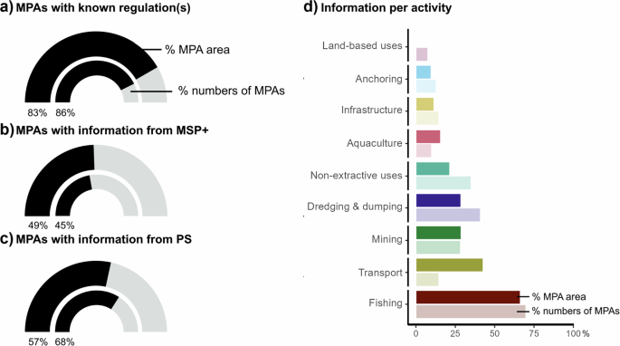
Overall summary of data available (at least one activity known as allowed, restricted or prohibited). a data available from all datasets. b data from MSP+. c data from PS. d data per activity, including all datasets. Area calculation included MPAs subdivision in zones of different regulations. Data from expert-based assessments are included in (a) and (d); we do not provide a specific panel for these assessments as they are available for less than 100 MPAs.
Secondly, we mapped the regulations of activities in EU MPAs, combining data from MSP+, PS, and the two expert-based assessments available, to improve the quality of the analyses. We investigated whether there were authorizations, restrictions, or prohibitions for the nine activities detailed above and in Fig. 1. This second analysis provided an overview, from the legal framework, of the most and least widespread regulations and combinations of regulations.
Computing results in numbers of MPAs and MPA area
For the two analyses described in the previous section, we provide results in terms of percentage of MPAs and MPA area. Except for identified MPA subdivisions in zones, data from PS and expert-based assessments were formatted at the scale of the MPA, so regulations they included applied to the whole MPA area. In contrast, if the regulation about an activity came from the MSP+ dataset, we used the area of the activity polygon reported in MSP+ (Fig. S1). Data formatted as points and lines could not be included in area computation (e.g., infrastructures like harbors, dredging sites). For land-based activities, we only provide results in MPA numbers (and not MPA area), because they are located on the shore and are formatted as points (e.g., sewage plants).
Statistical analyses and software used
We tested whether the distribution of authorizations, prohibitions, and restrictions in terms of MPA area varied across activities and from an independent distribution using Chi-square tests of independence (using the stats R package). We provide results for the main sea regions (North-East Atlantic Ocean, Mediterranean, Black and Baltic Seas), countries, and MPA designation types (nationally designated MPAs, Natura 2000, and regional conventions) in supplementary materials.
Formatting, maps, plots, calculations, and statistical analyses were run on R and QGIS, notably using sf and ggplot2 packages56,57,58,59. For the area calculations, national waters of EU Member States were obtained by merging inshore waters (from the Marine Strategy Framework Directive framework) and reported Economic Exclusive Zones32,60.
Results
Data availability of publicly accessible data sources (MSP+ and PS datasets)
We found no information (i.e., authorization, restriction, or prohibition) for 14.5% of MPAs and 16.6% of MPA area, and information on at least one of the nine activities for 85.5% of MPAs (4,149 MPAs) and 83.4% of MPA area (Figs. 2 and S2). The most reported activities in MPAs were fishing activities (regulations found in 65.7% of MPA area), transport (42.1%), mining (28.1%), dredging/dumping (28.0%), and non-extractive uses (20.9%; Fig. 2). Other activities were known for less than 20% of MPA area.
Expert-based assessments showed lower rates of unknown compared to publicly available databases (Fig. S3). Assessed Portuguese MPAs showed information for all activities but transport and land-based uses; OSPAR MPAs had information about fishing for all MPAs but one and were missing data on other activities like mining or dredging.
The MSP+ dataset contained data for 2,164 MPAs (44.5% of all EU MPAs, 48.9% of MPA area; Fig. 2). The most reported activities in MPAs from the MSP+ dataset were transport (14.0% of MPAs), fishing (13.9%), infrastructure (12.9%), and non-extractive activities (12.4%; Fig. 3). Only 1.4% of MPAs with MSP+ data showed at least one prohibition (of anchoring or mining); 99.2% of MPAs with MSP+ data showed authorization(s). At the time of the study, EMODnet data (that overlapped with MPAs) was available for 20 countries. Eighteen countries had published their MSP, and 18 countries had published a national geoportal with geospatial data that could be used in this study (Fig. 18). Data availability varied across countries: for 10 EU coastal countries, MSP+ contained some data (all activities combined) for less than 50% of their MPAs (Fig. 3). Most reported data was not comprehensive for each category of activities (e.g., no detailed data on the type or scale of uses within categories, including for fishing gears, dredging, or recreational uses).
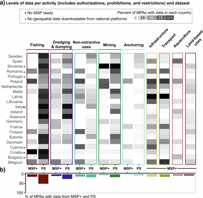
Percentages of MPAs with data for each of the nine activities from the MSP+ and PS datasets. a Data available in each country, countries that did not have a published MSP (as of November 2023), or a downloadable geospatial dataset (as in January 2023) are indicated. b Data available at the EU scale (only MSP+ data is available for infrastructure, transports, aquaculture, land-based uses).
The PS dataset contained data for 3,312 MPAs (68.2% of EU MPAs, 56.8% of MPA area; Fig. 2), compiled from MPA management plans (or equivalent). The most reported activities in MPAs from the PS dataset were fishing (68.1% of MPAs), dredging/dumping (34.4%), mining (25.4%), and non-extractive uses (21.5%; Fig. 3). The PS dataset reported data about restrictions (61.8% of MPAs) and prohibitions in MPAs (27.5%), more than authorizations (0.9%). For 15 countries (68.2% of coastal EU countries), PS contained data for at least 50% of their MPAs (Fig. 3). Reporting on activities was not comprehensive enough in the database (e.g., the number of gears included was too limited), and types of restrictions were insufficiently detailed (both due to limited information from the management plans and from the PS standardization process).
Mapping activities regulations in EU MPAs (PS, MSP+, and expert-based assessments)
Sixty-nine percent of EU MPA area allowed at least one activity, whereas at least one activity was found prohibited in 14.8% of the MPA area (Fig. 4). We found slightly larger area of prohibitions in the North-East Atlantic Ocean compared to other regions (Fig. S4), and in national designations compared to Natura 2000 or MPAs from regional conventions (Fig. S5). In terms of activities subject to restrictions (but not fully prohibited), at least 1 activity was restricted in 31.6% of the MPA area (two activities in most cases, Fig. S6). The types of restrictions were not formatted in specific fields in the databases used (and, when included, consisted of copy-pasted sections of legal texts), which prevented quantification. From a qualitative analysis, these restrictions could either be scale-related (vessel size for transport, fishing gears) or temporal restrictions (seasonal restrictions for fishing or access, or when specific operations are conducted). Restrictions could also reflect whether an activity was submitted to authorization, especially in the case of highly regulated activities, such as mining (as it could be inferred from the limited formatting in the PS dataset).
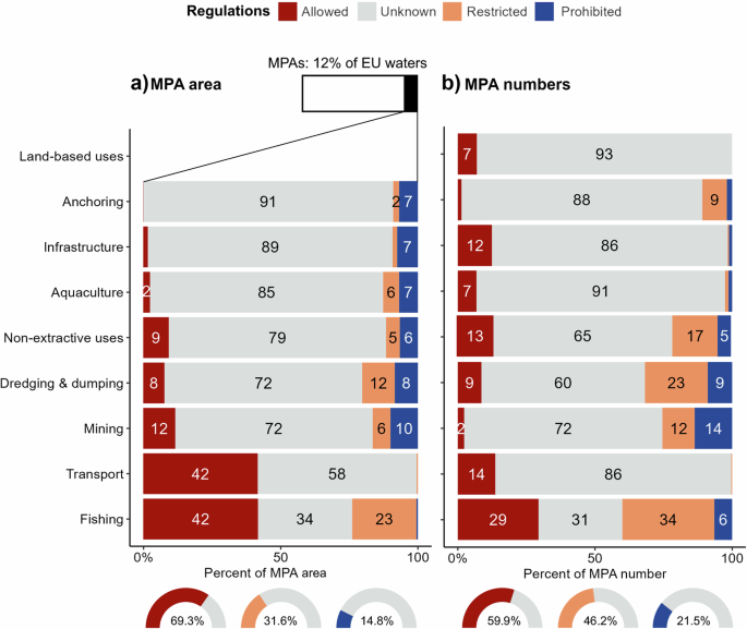
Distribution of regulations per category of activities. a Regulations in percent of MPA area, pie charts below the barplots display the percentage of MPA area with at least one activity known as allowed/restricted/prohibited. Area was calculated using data formatted as the MPA scale (PS, expert-based assessments; but considering MPA subdivision in zones of different regulations) and as polygons within MPAs (MSP+, points, and lines could not be used). We do not provide any area computation for land-based activities as they are formatted as nearshore points. Because points and lines were excluded, area was underestimated, for example in the case of infrastructures (ports were formatted as points). b Regulations in number of MPAs, pie charts show the percentage of MPA number with at least one activity known as allowed/restricted/prohibited.
The distribution of MPA area showing authorization, prohibition, or restriction varied among activities (Chi-square = 1,518,649, df =21, p-value < 0.001, Fig. 4A, B, see Fig. S7 for statistical results). Fishing and transport were the activities most described as allowed within MPAs (>40% of MPA area; Fig. 4). Altogether, fishing, mining, or dredging/dumping were allowed in 47.8% MPA area. Mining was the only activity reported as prohibited in at least 10% of MPA area (Fig. 4).
In further details, fishing activities were found to be prohibited in 0.4% of the MPA area, most often together with non-extractive uses (Fig. S6; results in numbers of MPAs are presented in Fig. 4B, see Fig. 5 for results per country for most reported activities, and Fig. S5 for designation types). Fishing was reported as allowed in 41.8% of MPA area (either unregulated or highly impactful gears being allowed without any known limitation) and restricted in some ways in 23.5% of the MPA area (Fig. 5). Fishing activities were restricted to low impactful gears in 8.6% of the MPA area where some gears could be restricted (including for some periods only; Fig. S8). Dredging/dumping was found to be prohibited in 8.3% of the MPA area (prohibited together with mining in most cases, Fig. S6). It was allowed in 7.7% of MPA area (including military activities such as explosive experiments, Fig. S8) and restricted in 11.9%. Mining was prohibited in 9.9%, allowed in 11.7%, and restricted in 6.5% of the MPA area (mostly oil and gas extraction or unspecified mining, Fig. S8). Transport was allowed in 41.7% of MPA area. Infrastructures, non-extractive uses, anchoring, and aquaculture activities were poorly reported (25% of MPA area or less) but found to be prohibited in 6.5-7.5% of the MPA area. Land-based uses were described as allowed in 7% of MPAs.
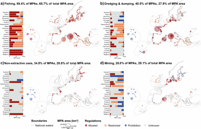
Distribution of regulations for four activities across countries and mapped in EU seas. a Regulations for fisheries. b Regulations for dredging and dumping. c Regulations for non-extractive uses. d Regulations for mining activities. The overall percentages of data found for each activity are given in the title both in numbers of MPAs and MPA area. Only activities known for at least 20% of the numbers of MPAs and MPA area are presented; other activities are presented in Fig. S9. The maps show the distribution of regulations at the MPA scale (the regulation might apply to only part of the MPA area), and the level of color opacity illustrates MPA overlapping. The barplots show the regulations in terms of area (i.e., including MPA subdivision in zones, and if an activity is reported as allowed because of a line or point, it will be shown as allowed in the map, but not included in the area calculation). Countries are displayed in alphabetical order.
Discussion
Our study highlights the need for significant improvements in data collection on the regulation of activities in MPAs, including for maritime activities of high impact, such as mining, fishing, and dredging. When data was available, our results showed limited restrictions of activities in EU MPAs, though our results cannot be understood without a thorough analysis of data collection and formatting schemes.
There are indeed critical gaps in reporting, centralizing, and standardizing data on regulations of activities in EU MPAs, as illustrated from data sources gathered here, including MPA, MSP, and other activity-focused databases. All datasets used showed different levels of standardization and reported a limited set of activities19,26,45,61. The resulting data used here could be partially inaccurate (e.g., we found fishing activities to be overall restricted in Greece, which is unlikely62). Moreover, there were ongoing planning processes that were not yet shared as spatial data at the time of data collection, as illustrated by the very little data about the yet-developing projects of windparks in MPAs. It is worth noting that if some activities are not relevant in some MPAs (e.g., as there is nothing to dredge nor mine), this information would likely not be reported, and given the inconsistency in reporting, it cannot be assumed that unknowns correspond to the absence of the activity, thereby limiting the interpretation of our results. Our research therefore provides an initial and thorough overview of available data on regulations in EU MPAs. We discuss the lack of data in light of the legal frameworks, challenges, and recommendations for standardizing legal data, and we also examine the regulations found for activities in EU MPAs.
Higher rates of information were expected, as the need for data on maritime activities for decision-making has been highlighted several times by European institutions13,63,64, and data collection is at the core of several EU environmental directives (including the MSP, Marine Strategy Framework Directive, two Directives related to environmental impact assessments, and the INSPIRE directive for an INfrastructure for SPatial InfoRmation in the European community). Member States also have reporting obligations under Regional Sea Conventions or sectoral schemes (e.g., to the International Maritime Organization), but little updated data was available at the time of searching (for OSPAR see Roessger et al.19). In addition, many activities should a priori go through authorization or derogation processes, under EU and national legislations, such as mining, dredging, and renewable energy infrastructure (activities legally defined as “plans” or “projects” under Article 6 of the Habitats Directive, though their authorization and impacts are yet poorly monitored and investigated at EU scale65,66,67). Finally, access to this kind of information is also a prerequisite for informed participation61, as specified by the Aarhus convention, as well as European and national legislation. There is however no explicit EU obligation to report regulations of activities in EU MPAs68,69.
Even after decades of implementing environmental legislation in the EU, the provision of standardized and up-to-date data on regulations in MPAs continues to lag behind. So far, a large share of EU data collection for environmental policies is limited to environmental data, impact assessment processes to guide authorization (e.g., reports are required under associated EU Directives), and fisheries activities (the Common Fishery Policy has a dedicated Data Collection Framework Regulation for catch and vessel monitoring). EU Directives also grant much discretion to the Member States regarding their implementation, including data to share, the format of MSPs (though detailed guidance was provided, elaborated by IOC and the European Commission13), the pressure assessments under the Marine Strategy Framework Directive, and the use, accessibility, and format of management plans for Natura 2000 MPAs. This flexibility could be seen as an opportunity to gather nationally relevant data. However, the broad nature of reporting obligations under EU law likely contributed to the low availability and/or accessibility of standardized and centralized regulatory data, with a high variability across countries34,45,68,70,71.
Even given the limited implementation of EU and national legal frameworks, it is very likely that more data already exists about activity planning and regulation. Its access, formatting, and connection to environmental policies are lacking. Indeed, just at MPA scale, there is a large corpus of additional legal texts (including rulings) and reports to consider for individual MPAs or per type of MPA (e.g., for some MPAs, rules are defined in the decree of creation, while for others, they are found in additional documents). It is also possible that some regulations would not be included in MPA management plans (or equivalent), because they are regulated through other legal tools (which, if not included in the MSP, would likely have been missed in this study). At the MPA scale, management bodies often do the work of synthesizing and mapping activities and their regulations from these different sources, but it then needs to be into converted into geospatial data and transferred to national and European authorities and databases.
Wider spatial planning initiatives and platforms, such as the activity-focused databases compiled in the MSP+ dataset, could therefore give the opportunity to gather all the data mentioned (e.g., MPA-specific legislation, authorization processes). So far, they included very little data regarding what is protected and how, as illustrated by the very limited mapping of regulations in MPAs, and still integrate few of many data sources (e.g., terrestrial uses or impact assessments72; on integration of environmental issues in MSPs, see for example15,73,74,75). Regarding fisheries, despite high research and political interest in mapping fishing restrictions in MPAs, by 2024, EU institutions were only conducting an initial description of the level of measures in marine Natura 2000 MPAs76, asking states to score how much of the fisheries measures have been implemented for site-specific ecological features and report on bottom trawling prohibitions. Therefore, there is a great need for national agencies to collect, process, and share regulatory data, as several EU states have already started doing77.
To date, investigating regulations in MPAs therefore requires a broad scan of legal texts, which are not easy to access or understand, as legal and governance systems overlap22,62,69,78. Issues in standardizing and centralizing data are not specific to MPAs’ legal framework, but to maritime activities in general71, their occurrence, pressures and impacts. Coordinating initiatives and connecting data sources would involve a massive amount of work to design and update relevant data collection schemes (Fig. 6). It would require addressing deeper and persistent issues, including States’ incomplete implementation with regards to reporting obligations mentioned above65,66 (notably because activity-related data is considered sensitive to share71), overall insufficient means and administrative capacities, and coordination among competent administrations to map, standardize (see further below), update, and share data79,80. It would also require to connect the different scientific and policy communities (i.e., epistemic communities) working on conservation or maritime planning from various approaches (legal, ecology, economy, etc.), from different perspectives, using different tools (e.g., spatialized and summarized descriptors versus detailed texts in legal language)27,28, or having different priorities with regards to environmental policies.
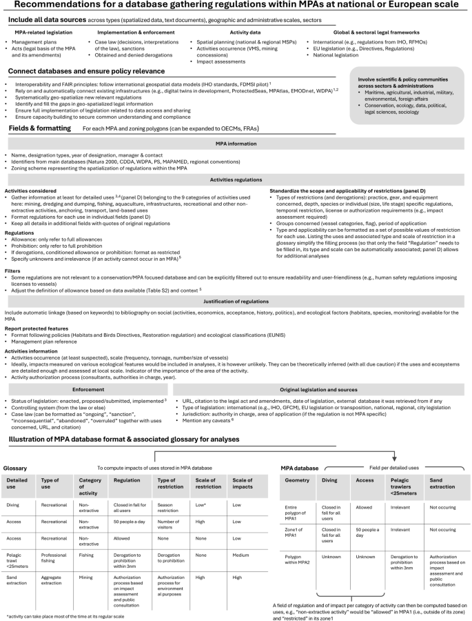
Recommendation to compile regulatory data for EU MPAS. 1. See national and regional initiatives (e.g., refs. 70,132,133,), IHO S-100, FDMSI pilot, or CINEA technical work38,82. 2. See the references for these initiatives and databases32,35,36,43. 3. MPA Guide guidance on protection levels and stages of establishment53. 4. On listing sea uses, see the detailed list of uses in Aminian-Biquet et al., 2024, EMODnet reporting, VASAB glossary of sea uses32,46,134. 5. Authorization might for example mean that most of the activity can take place (in terms of vessels, users, volume extracted); e.g., in this study, because unknowns were undistinguishable from unmapped or irrelevant activities, for some activities, authorizations were based on highly impactful activities being allowed. 6. See for example133. Acronyms: IHO: International Hydrographic Organization; GFCM: General Fisheries Commission for the Mediterranean; RFMOs: Regional Fishery Management Organizations; OECM: Other Effective Conservation Management; FRA: Fisheries Restricted Areas; VMS: Vessel Monitoring System; EUNIS: European Nature Information System.
There are now initiatives and growing collaboration aiming at achieving accessible, comprehensive, interoperable, and interconnected data platforms. For example, some MSP or biodiversity-focused projects aim at improving data availability at national or regional levels (e.g., the THAL CHOR project70, the BIODIV’FRANCE77 LIFE project, the Greater North Sea Basin Initiative81). International initiatives have notably been developing centralized, standardized, and accessible data infrastructures and models to format and compile data, including the CINEA MSP technical group at European level37,82, the “Federated Marine Spatial Data Infrastructure” pilot led by OGC focusing data for navigational purposes at a global level (including IHO’s standards S-100, its associated working groups, and its MPA-focused data product S-12238,83,84), and the working groups of the United Nations’ Committee of Experts on Global Geospatial Information Management (UNGGIM85).
As illustrated by the legislation and initiatives mentioned, spatial planning, data availability, and associated technologies are progressing rapidly. Yet the challenges of designing indicators that standardize regulations and correctly transmit legal information remain poorly investigated in detail29,86 (but see for example the ongoing NAWRAS initiative87, assessing ocean legal protection using artificial intelligence). Like all indicators, legal ones simplify reality, which can lead to misunderstandings (some small differences between Member States may seem insignificant to non-experts) or instrumentalization (adoption of a legal framework to meet indicators, while its implementation is very weak)27. As the first step to move forward, we illustrated in Fig. 6 the key steps in ensuring the comprehensiveness and relevance of a dataset focusing on regulations in EU MPAs (though it could be expanded to other spatial planning tools). Describing activities should include a detailed formatting of practices (e.g., a field per use) and, if ever possible, an estimation of their scale (e.g., frequency of dredging). A more detailed synthetization of regulations was particularly missing in the data analyzed here, while it could have been summarized by the type of restriction (e.g., seasonal, species-related, specific to a practice/a group, specifying their area/MPA zone of application; Fig. 6), as increasingly implemented for example in the MPAtlas35 and MAPAMED88 web platforms and databases. To fully apprehend the applicability and scope of these rules, indicators should be clearly linked to the legislation(s) specifying the constraints, the governance and implementation process86, and its applicability (e.g., national legislation applies differently to national and EU fleets in the Economic Exclusive Zone). Our recommendations (Fig. 6) are aimed at policy and technical actors to ensure the effectiveness of future initiatives in collecting and standardizing regulation data, as would be necessary in particular to monitor the implementation of the Biodiversity strategy implementation. Overall, mainstreaming the use of these legal indicators can improve the recognition of on-the-ground achievements. However, these indicators cannot be the only approach for describing the actions and effects of MPAs because they often focus on specific aspects (sanctions, prohibitions) and can overlook other important dimensions of the work of managers (collaboration with stakeholders, raising awareness about environmental issues, or implementing the polluter pays principle).
Despite these clear gaps in data availability, if MPAs were designed to implement strict protection (i.e., high constrain on activities), one would expect this to be more explicit from their legal status and their management plans. It is clear that EU MPAs have been designated in peopled places, where many human activities could occur33,89. Today, there are no European-wide obligations for EU MPAs to restrict activities, though Member States must establish conservation measures in Natura 2000 MPAs, which make up 70% of the MPA area and highly overlap with the nationally designated MPAs14. We found limited regulations over most activities and significant rates of authorizations of impactful activities, in line with previous studies that showed low protection levels of subsets of EU MPAs, and limited and/or delayed conservation measures implemented in Natura 2000 MPAs17,18,44,90,91,92,93.
In the case of fisheries, they were allowed in more than 40%, restricted in less than 25%, and prohibited in 0.4% of MPA area, in line with research showing little restrictions and large occurrence of fishing operations24,25,94,95. As we discussed above the need to include the context of legal data, it should be noted that in the EU, the Common Fishery Policy has been perceived as an important obstacle in regulating fishing activities (from national or EU fleets)22. Indeed, Member States need to engage in negotiations with each other to regulate fleets in about half of the current EU MPA area (located in their Economic Exclusive Zones, above 12 nautical miles). So far, most of the fisheries restrictions in MPAs are currently located in territorial waters, where Member States have sovereignty (except for historical fishing rights96).
In contrast with fishing activities, very little was known about other activities that can be considered as incompatible with conservation objectives (<30% of MPA area with regulation data), including mining or dredging and associated dumping53, which will likely expand in Europe in coming years97. Other activities investigated in this study were either found to be allowed in a large MPA area (transport, notably because shipping lines were mapped In EMODnet and MSPs) or poorly reported in the studied datasets (aquaculture, anchoring, non-extractive uses, land-based uses, and infrastructures). Yet, they have been reported as potential or significant threats to biodiversity33,98,99,100,101,102,103,104,105,106,107,108, and aquaculture and offshore wind energy infrastructure are notably expected to grow in coming years107,109,110.
For several activities and most of the MPA area, MPA legislation has led to increasing but limited restrictions (e.g., limited to increasing steps and delays in the approval process111,112), with ultimately questionable ecological effects. MPAs have been catalyzers of change in practices, for example in mainstreaming best practices for transport, harbors, diving or anchoring, leading the development of fishing reserves and no-take zones, or increasing collaboration among actors113,114,115,116. The extent of these changes remains difficult to describe, and they might have been limited to small scales, as management plans seem to include limited restrictions and prohibitions for most activities. In each MPA, many factors could have driven the choices to either regulate some uses or avoid doing so117,118,119, including the complex legal framework (as illustrated with the Common Fishery Policy above) and the limited capacity and means deployed to engage in negotiations so far. Importantly, regulating activities in MPAs requires addressing conflicts resulting from diverging expectations about MPAs among actors120,121,122,123, and the socio-economic consequences of restricting activities17,112,124,125,126,127. Today, several European actors are increasingly pushing for an EU-wide change of MPAs to further restrict activities, including bans on the most impactful fishing gears, while other stakeholders, particularly the fishery sector, oppose additional restrictions40,128,129,130,131.
In conclusion, this European context highlights that decades of delay in collecting and sharing information on activity data, coupled with the difficulty of conceptualizing such data systems, are hampering current policy development and informed public participation. Monitoring regulations in MPAs is an important matter for all the reasons evoked above, but also because the lack of data can be used as an argument for not addressing activities whose extent and impact are uncertain. We provided recommendations concerning the reporting requirements for standardized regulatory data. As illustrated in Fig. 6, they need to be carefully designed and explicit enough, with the possibility of adding formatted data on activities, their restrictions, and scale, to avoid turning such reporting into a box-ticking exercise (i.e., carrying out only the minimum reporting to appear compliant) and misrepresenting realities on the ground. Our study also highlights the need to connect existing data sources, by standardizing and homogenizing data reporting of regulations at sea, so that we can properly analyze MPAs’ legal frameworks, governance, and politics. All these steps are necessary to understand the possibilities of MPAs to regulate activities and the consequences of these regulations (and how they are achieved) on ecosystem conservation and human societies.


Responses