The spatial coupling and its influencing mechanism between rural human-habitat heritage and key rural tourism villages in China

Introduction
Rural human-habitat heritage is a kind of cultural and natural heritage in rural areas with living and production functions as the main body and certain vitality. It is an organic combination of living heritage and rural community, including material heritage and intangible heritage. Rural human-settlement heritage evolves continuously with the development of The Times and is rooted in local rural communities, and is used, maintained and inherited by community residents1,2,3,4. Due to the uniqueness and ornamental value of rural habitat heritage, rural habitat heritage is gradually becoming an important attraction for rural tourism5,6, which endows rural tourism with a cultural atmosphere. Conversely, the development of rural tourism can also become an important means for the revitalization and utilization of rural residential heritage7,8. Thus, there is a mutually beneficial relationship between rural habitat heritage and rural tourism. As rural habitat heritage and rural tourism and the coupling relationship between them are the result of the long-term breeding of local cultural ecological environment, their formation and development have a certain internal correlation with regional geographical environment and human background, and to a certain extent, they are the geographical paradigm embodiment of the coordinated development of human-land relationship9. Therefore, exploring the spatial coupling characteristics and influencing mechanism of rural habitat heritage and rural tourism from the perspective of space can better explain the spatial coupling law process and influencing factors between the two, and explore the connotation and theoretical mechanism of cultural heritage-environment interaction, which is conducive to the protection and activation of rural habitat heritage and the high-quality development of rural tourism.
Research into the legacy of human-settlement heritage began in the late 1990s. Scholars initially focused on material heritage such as cultural relics buildings, traditional dwellings, historic towns and neighborhoods, and later expanded to intangible heritage, such as folk customs, traditional dances and skills, and traditional villages. The scale of attention also shifted from cultural preservation units and building mono to the overall social environment of historic towns, historic blocks, traditional villages2,3,10,11. In recent years, with the rise of research hotspots on heritage revitalization and rural tourism, some scholars have begun to focus on rural habitat heritage, involving many disciplines such as history, geography, anthropology, sociology, tourism, etc. Related theoretical research and applied research results show the characteristics of interdisciplinary and multi-perspective research. In terms of research content, existing studies have mainly focused on the systematic protection, development and utilization, spatial distribution characteristics, influencing factors and influencing mechanisms of individual elements of rural human-settlements heritage. For example, ancient settlements12, traditional villages13,14, intangible cultural heritage15, famous historical and cultural cities and towns and villages16, agricultural cultural heritage17,18, traditional villages. In terms of research methods, scholars have gradually changed from the initial qualitative descriptions and case studies to quantitative analysis such as spatial analysis and econometric model. For example, GIS spatial analysis methods (nearest neighbor index, kernel density analysis, center of gravity shift model), buffer analysis method15, regression model13, geographical weighted regression model14, Geodetector model13, Robust geographical detector19.
Tourism village have been a hot research field of rural geography in recent years. Research on tourism villages mainly focuses on the spatial distribution and its influencing factors of rural tourism villages. In the research field of tourism village spatial pattern, different scholars have analyzed the spatial structure and temporal and spatial evolution characteristics of key tourism villages at national scale7,20,21,22, river basin scale23, urban agglomeration scale24, and provincial administrative unit scale25 by using GIS spatial analysis method20,21. In this way, the spatial distribution law and development model of key rural tourism villages are systematically revealed. In the research field of influencing factors of spatial distribution of tourism villages, different scholars have used different typical regions as examples. Buffer analysis method20, spatial overlay analysis22, regression model13, geographical weighted regression model24, and geographical detector model23,25 to analyze the linear, non-linear and interactive effect of natural environment factors (terrain, climate, ecological environment and hydrology), socio-economic factors (population, economy, urbanization, tourist source market), road conditions, resource endowments, cultural environment, employment, and policies factors on the spatial distribution of key tourism villages20,22,24,26,27. In general, the content of research on key rural tourism villages has gradually shifted from the analysis of spatial distribution rules to the discussion of influencing factors and their influencing mechanisms, and the research depth and breadth have gradually improved.
In the research field of spatial coupling between rural human-habitat heritage (RHH) and key rural tourism villages (RTV), in recent years, several scholars have recently started to analyze the spatial coupling relationship, spatial dislocation, and influencing factors between traditional villages and rural tourism key villages in different typical case areas. For example, Li et al.28 attempted to analyze the distribution pattern and spatial correlation of traditional villages and RTV in Henan Province, China, and explored the relationship between spatial correlation and regional natural environment and social and economic factors28. Wu et al.26 used the analysis methods of imbalance index, gravity center model, spatial dislocation index and geographical detector to separate the spatial dislocation relationship between traditional villages and RTV in Shanxi Province and their leading influencing factors, and found that multiple factors jointly created the spatial dislocation pattern between traditional villages and RTV, among which natural environment and resource endowment were internal factors. Regional economy is the basic driving force, while population, employment and traffic conditions are external factors26. Combing through the existing research results, we can find that there are still two shortcomings in the existing studies: Firstly, the existing studies pay more attention to the spatial coupling relationship between traditional villages and the RTV, and pay less attention to the spatial coupling relationship between all elements of RHH and RTV. Secondly, existing studies have paid little attention to the factors and mechanisms of the spatial coupling relationship between RHH and RTV.
China’s 5000 years of agricultural civilization has left countless rural settlements, and the rapid development of rural tourism has resulted in the emergence of a large number of key tourism villages, providing a suitable case study area for this study. In the context of industrialization, urbanization and globalization, the social economy and culture of China’s rural areas have suffered unprecedented impacts. In some areas, the rural residential heritage faces such difficulties as lack of awareness of protection and inheritance, serious rundown and damage, disappearance of traditional culture, regional imbalance of protection and development, and unbalanced spatial distribution4,5, on the other hand, the spatial distribution of key tourism villages is extremely unbalanced, which leads to a certain degree of dislocation in the spatial distribution of RHH and RTV. At the same time, previous studies failed to systematically analyze the influencing factors and interaction mechanisms of the spatial coupling relationship between RHH and RTV at the national level, which restricted decision makers from formulating coordinated development measures between RHH and RTV at the macro level. Based on this, this study takes China’s RHH and rural tourism key villages as the research object, and adopts bivariate spatial autocorrelation method and spatial coupling coordination degree model to analyze the spatial coupling relationship between RHH and RTV. Then, the OLS, GWR, and OPGD model are integrated to systematically analyze the linear influencing, spatial heterogeneity effect, and interactive effect of natural environment and socio-economic factors on the spatial coupling coordination level between RHH and RTV in China, and explore the interactive influence mechanism. This study will further expand the theoretical research on the spatial coupling mechanism between RHH and RTV, and provide theoretical reference and data support for the coordinated development and high-quality development of RHH and RTV in China.
Materials and methods
The research framework and content of this study are shown in Fig. 1, which is divided into three parts (Fig. 1). The first part is the construction of multi-source database. The multi-source data include vector point data of rural human-habitat heritage and key rural tourism villages, as well as influencing factor data of their coupling relationship. The second part is a quantitatively analysis of the spatial coupling pattern between RHH and RTV in China by using the bivariate spatial autocorrelation model and the spatial coupling coordination model. The third part integrates the OLS, GWR, and OPGD model to systematically analyze the linear influencing, spatial heterogeneity effect, and interactive effect of natural environment, socio-economic factors and socio-cultural factors on the spatial coupling coordination level between RHH and RTV, and explore the interaction influencing mechanism of influencing factors.

The research framework and content of this study.
Study area and data source
This study takes all county-level cities in China as the research unit, including 2851 county-level cities excluding Hong Kong, Macao, Taiwan and other data-free regions (Fig. 2a, b). Rural material landscapes and cultural artistic conception have been cultivated by the farming civilization of China for thousands of years, forming the rural human-settlement heritage with wide distribution, rich diversity and outstanding value. They are important carriers of rural cultural values and important resources for rural sustainable development. Refer to previous research results1,2,3,4, and integrating the elements and characteristics of the existing rural human settlement heritage, this paper believes that rural human settlement heritage can be mainly divided into three types: traditional settlement heritage in villages and towns, rural productive landscape heritage, and intangible cultural heritage formed based on long-term production and life in settlements (Table 1). China’s rural habitat heritage includes 10,492 traditional settlement heritages in villages and towns, 157 productive landscape heritages in villages, and 1432 intangible cultural heritages based on long-term production and life in concentrated communities (Fig. 2c). China’s key rural tourism villages are rural tourism demonstration villages with rich cultural and tourism resources, better protection of ecological environment and traditional culture, better rural tourism infrastructure and public services, mature and high-quality tourism product systems, beautiful ecological environment and livability, and obvious benefits of employment and prosperity. By the end of 2022, China has built a total of 1399 national-level rural tourism key villages (Fig. 2d). In the context of industrialization, urbanization and globalization, the social economy and culture of China’s rural areas have been affected as never before. In some areas, the rural residential heritage has encountered difficulties such as lack of awareness of protection and inheritance, serious rundown and damage, disappearance of traditional culture, regional imbalance in the degree of protection and development, and unbalanced spatial distribution (Fig. 2c). There is an urgent need for effective conservation and restoration. The development level of rural tourism is uneven, the quality of tourism facilities and services in some villages needs to be improved, and the spatial distribution of key tourism villages is extremely unbalanced (Fig. 2d).

a China’s administrative divisions and county boundaries, (b) topographic map of China, (c) spatial distribution of rural human-habitat heritage of China, and (d) spatial distribution of key rural tourism villages of China.
The data types used in this study mainly include six aspects: (1) Administrative divisions and basic geographic information data (Table 2). China county administrative divisions, drainage, roads, such as vector data are from China academy of sciences, resources and environment science and data center (RESDC) (https://www.resdc.cn/Default.aspx) (Table 2). (2) Vector data of rural human-habitat heritage and key rural tourism villages. By the end of 2022, China national historical and cultural town and village, Chinese national traditional villages, Chinese minority ethnic village, China agricultural cultural heritage, world cultural heritage (rural areas), and China’s intangible cultural heritage list from China’s state council web site (Table 2). (3) Public service facilities and hotel homestay vector data. Public service facilities, hotels, and in 2022 the home stay facility vector data derived from RESDC (Table 2). (4) Vector data of cultural institutions. China museum, memorial hall, museum, cultural centers, performing arts groups such as POI data in 2022 are from RESDC (Table 2). (5) Remote sensing data. Elevation, annual precipitation of grid data in 2022 from RESDC (Table 2). The raster data of land use in 2022 are derived from the research results of Yang et al.29 (data has been updated to 2022)29. (6) Statistical yearbook data. China’s total population, GDP and per capita GDP of counties in 2022 are derived from the statistical yearbook of China’s provinces, prefectures and municipalities, and statistical bulletins.
Theoretical influencing mechanism of the spatial coupling relationship between rural human-habitat heritage (RHH) and key rural tourism villages (RTV)
Human-habitat heritage refers to the cultural heritage with the living function and life production function as the main body, and the interaction between man and nature and man and history. At the same time, it is also the material living heritage with heritage and life attributes2,3,5. The vitality of human-habitat heritage sites is closely related to the communities living in them, reflecting the vitality of the communities. Rural human-habitat heritage is a kind of cultural heritage with certain vitality in rural areas, with living and production functions as the main body. It is the organic combination of living heritage and rural community, including material heritage and intangible heritage. Rural human-settlement heritage is a living heritage, continuously evolving and rooted in the local community, which is used, maintained and passed on by community residents1,2,3,4. Key rural tourism villages refer to rural tourism demonstration villages with rich cultural and tourism resources, better protection of natural ecology and traditional culture, better rural tourism infrastructure and public services, mature and high quality tourism product system, beautiful and livable ecological environment, and obvious benefits of employment and prosperity22. Cultural heritage and natural tourism resources should be studied from the phenomenon of the evolution of natural landscape, because they are the result of the long-term breeding of local cultural ecological environment, and their formation and development have a certain internal correlation with regional geographical environment and human background, and to a certain extent, they embody the geographical paradigm of the coordinated development of human-land relations9. The formation and development of tourist villages are also closely related to their regional geographical environment and social and economic background22,27. The spatial distribution and its coupling relationship between rural human settlement heritage and rural tourism key villages is influenced by multiple factors, including economic development level, population, road traffic conditions, rural tourism infrastructure conditions, public service facilities conditions, social and cultural environment, terrain, climate, hydrology and eco-environment. These factors are intertwined and jointly shape the spatial coupling pattern of rural human-settlement heritage and rural tourism key villages26,27,28 (Fig. 3).

Theoretical influencing mechanism of natural environment and socio-economic factors.
From the theoretical influencing mechanism of each factors: (1) Economic development level. Economic development level is an important factor affecting the spatial distribution of rural human settlement heritage and rural tourism key villages20,21,22,23,24,28. In economically developed areas, rural tourism can often get more capital investment to promote the construction of infrastructure and the development of tourism products. Therefore, the rural residential heritage in these areas is easier to be protected and utilized, and has become an important resource to attract tourists. At the same time, areas with a high level of economic development have a relatively high level of income and quality of life for residents, which provides a broader market basis for rural tourism. (2) Population factors. Population factors have a direct impact on the spatial distribution of rural human settlement heritage and the key villages of rural tourism23,26,27. Densely populated areas are usually areas where cultural heritage is concentrated and tourism demand is strong. On the one hand, a large population means more inheritors and consumers of cultural heritage, which is conducive to the preservation and dissemination of rural residential heritage. On the other hand, the population gathering also brings greater tourism market potential and promotes the formation and development of key villages for rural tourism. (3) Rural infrastructure conditions. The convenience of road transportation is a key factor in determining the accessibility and attractiveness of rural tourism26,27. In areas with well-developed road transportation, tourists can reach rural tourism destinations more conveniently, thus increasing the passenger flow of rural tourism. At the same time, good road traffic conditions are also conducive to the dissemination and promotion of rural human settlement heritage, enhancing its visibility and influence. The number of hotels and homestays reflects the reception capacity of rural tourism destinations and the development potential of rural tourism. (4) The conditions of public service facilities. The perfection of public service facilities is directly related to the service quality of rural tourism and tourists’ satisfaction9,22,28. In areas with sound public service facilities, tourists can enjoy a more comfortable and convenient travel experience, which helps to enhance the attraction and competitiveness of rural tourism. At the same time, good infrastructure also provides strong support for the protection and utilization of rural residential heritage. (5) Socio-cultural environment factors. Social and cultural environment factors have a profound impact on the spatial distribution of rural human settlement heritage and the key villages of rural tourism22. The social and cultural backgrounds of different regions give birth to the distinctive rural human settlement heritage, which is an important resource to attract tourists. At the same time, social and cultural factors also affect the consumption habits and market demand of rural tourism, which indirectly affects the formation and development of the key villages of rural tourism. (6) Terrain and climate factors. Terrain and climate factors can indirectly affect the distribution of rural human settlement heritage and rural tourism key villages by affecting regional ecological environment and human production and living conditions20,26,28. (7) Eco-environmental factors. Ecoenvironment is one of the important attractions of rural tourism, and it is also the basis for the survival and development of rural residential heritage22,28,30. A beautiful ecological environment can improve the quality and attractiveness of rural tourism, and further promote the formation of key villages for rural tourism. At the same time, a good ecological environment is also conducive to the protection and inheritance of rural residential heritage. The two complement each other and together constitute the unique charm of rural tourism.
Selection and measurement of influencing factors
Based on the theoretical driving mechanism framework (Fig. 3) and with reference to existing research results9,12,13,14,18,20,21,22,23,24,25,26,27,28,30, this paper constructed a driving factor indicator system for the spatial coupling relationship between RHH and RTV (Table 3).
As shown in Table 3, the driving factor indicator system is composed of seven factors, including economic development level, population, road traffic conditions, rural tourism infrastructure conditions, public service facilities conditions, social and cultural environment, terrain, climate, hydrology and eco-environment. The specific quantification methods of some indicators are as follows: (1) The perfection of public service facilities. The density of public service facilities per square kilometer is used to characterize the perfection of public service facilities. Public service facilities include administration and community services, social welfare and security, medical and health care, postal and telecommunication services and commercial and financial services. (2) The number of cultural institutions. The number of cultural institutions includes the number of museums, memorials, art galleries, cultural centers and art performing groups. (3) Forest coverage rate. The proportion of the total area of county forest land to the total area of the study area was used to characterize. (4) Ecological land connectivity index (ELCI). ELCI was used to characterize ecological land connectivity. Connectivity reflects the functional connectivity among landscape components. When the structure of landscape components is conducive to the connectivity among landscape components, which is conducive to the operation of ecological flows such as matter, energy and information between landscape patterns31. The calculation formula:
({rm{CONNECT}}=frac{mathop{sum }nolimits_{j=k}^{n}{c}_{{ijk}}}{frac{{n}_{i}({n}_{i}-1)}{2}}times 100)
Where ({c}_{{ijk}}) is the connection status of plaques j and k associated with plaque type i within the critical distance. ({n}_{i}) is the number of patches of patch type i. The connectivity index ranges from [0,100].
Bivariate spatial autocorrelation method
Bivariate spatial autocorrelation is an effective method to explore local spatial autocorrelation, reflecting the degree of spatial correlation between two attributes32. With the help of GeoDa 1.14 software, the bivariate spatial autocorrelation method was used in this study to analyze whether there is a significant spatial correlation between the RHH and RTV. The calculation formula is as follows:
Where ({I}_{{rm{ur}}}) is the global bivariate Moran’s I index of between RHH and RTV. n is the number of spatial units. ({z}_{i}^{u}) is the number of RHH in space unit i. ({z}_{j}^{r}) is the number of RTV. ({w}_{{ij}}) is the spatial weight matrix.
Spatial coupling coordination degree model
Coupling degree originates from the physics concept, and was later introduced into geographical, social, and economic fields33,34. The coupling coordination degree can reflect the synergistic effect and equilibrium state between the two systems. This paper constructs the spatial coupling coordination model of RHH and RTV. The formula is as follows:
Where ({mu }_{i}) and ({mu }_{j}) are the standardized values of the number of RHH in spatial unit i and RTV in spatial unit j. C is the coupling degree. In view of the fact that coupling degree can only measure the correlation degree between dimensions, but cannot reflect the coordination level between dimensions, this paper further introduces the coupling coordination degree model. The formula is as follows:
Where D is the coupling coordination degree, the value range is 0-1. (alpha) and (beta) is the undetermined coefficient, representing the contribution degree of each dimension. This study assumes that the two dimensions are of equal importance, so (alpha) = (beta =,)0.5. The classification criteria of the coupling coordination types were: severe discoordination (0 < D(le)0.1), moderate discoordination (0.1 < D(le)0.3), mild discoordination (0.3 < D(le)0.45), basic coordination (0.45 < D(le)0.55), moderate coordination (0.55 < D(le)0.70).
Multiple linear regression model (OLS) and geographically weighted regression (GWR) model
This study takes into account the different factors affecting the spatial coupling coordination level in different regions of the study area, and the limitations of traditional linear regression models in the their “global” estimation31. Therefore, we used the OLS analysis module and GWR analysis module of GWR 4.0 software to estimate the global and local impact levels of each impact factor on the dependent variable, so as to more directly reflect the spatial disequilibrium characteristics of influencing factors and their changing trends.
(1) OLS model. The calculation formula of OLS model is as follows:
Where (varepsilon) is the error term, and ({beta }_{0}) is the regression constant. ({x}_{{ij}}) is explanatory variables, ({Y}_{j}) is explained variables.
(2) GWR model. The geographically weighted regression (GWR) model extends the traditional linear regression model, and its regression coefficient is no longer the assumed constant (({beta }_{0})) obtained by using global information, but obtained by local regression estimation, and changes with the change of spatial geographic location. The formula of the GWR model:
Where is the ({Y}_{i}) coupling coordination degree. (({{{S}}}_{i},{{{T}}}_{i})) is the central geographical position coordinate. ({beta }_{j}({S}_{i},{T}_{i})) is the jth regression parameter on point i. ({varepsilon }_{i}) is random error. The modified Akaike Information Criterion (AICc) was used to determine the optimal bandwidth. ({beta }_{j}({S}_{i},{T}_{i})) is the regression coefficient of GWR model. X is the matrix of explanatory variables, ({X}^{T}) is the transpose matrix of the explanatory variable, (W({S}_{i},{T}_{i})) Is the spatial weight matrix of the observation point i.
Optimal parameter GeoDetector model
The optimal parameter GeoDetector (OPGD) model is an improved model based on GeoDetector (GD) model, which can explore potential factors or explanatory variables from the perspective of space, and explore the potential interaction of geographical variables35,36. In the study, we use OPGD model to analyze the interaction effect of superposition between factors on the dependent variable (spatial coupling level of RHH and RTV). First, the factor detector module of the OPGD model is used to check the significance level of the factors. Then, the interaction detector module is used to analyze the interaction effect of superposition between factors on the dependent variable.
(1) Detection of influencing factors. Factor detector is used to analyze the influencing factors of spatial differentiation of dependent variables. The model formula is as follows:
Where q value indicates that the explanatory power of influencing factors to dependent variables. h is the number of layers of the influencing factor, Nh and N are the sample numbers, ({sigma }_{h}) and (sigma) is the variance of layer h and the whole study region. SSW is the sum of variances within layers; SST is the total variance.
(2) Detection of factor interactions. The interaction detector is used to identify the interaction between the influence factors, that is, to evaluate the influence of the combined effect of the factors (enhanced or weakened) on the dependent variable. The criteria for the various interaction types are shown in Fig. 4.

Interaction types between two independent variables and dependent variables.
Ethics approval and consent to participate
All participants provided written informed consent before taking part in the study. They were informed about the purpose, procedures, risks, and benefits of the research.
Results and analysis
Spatial coupling relationship between RHH and RTV in China
Spatial autocorrelation between RHH and RTV
In this study, the global bivariate spatial autocorrelation module of GeoDa 1.14 software was used to calculate the global bivariate Moran’s I index of RHH and RTV. The results of global bivariate spatial autocorrelation analysis show that the global bivariate Moran’s I index is 0.062, P-value is 0.002 (Z-value is 5.239), and the significance level test indicates that there is a significant positive spatial relationship between RHH and RTV.
The global binary Moran’s I index can globally evaluate the spatial correlation between RHH and RTV as a whole, but it ignores the instability of the spatial process. In order to judge the local spatial correlation pattern, we further use the local bivariate spatial autocorrelation module of GeoDa 1.14 software to calculate and draw the local spatial correlation pattern between RHH and RTV (Fig. 5). As shown in Fig. 5, there are four types of local spatial agglomeration: high-high agglomeration type (HH), low-high agglomeration type (LH), low-low agglomeration type (LL) and high-low agglomeration type (HL), among which HH, LH and HL occupy the highest proportion.
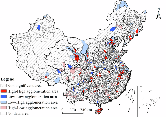
Spatial autocorrelation of RHH and RTV in China.
The HH area indicates that both the number of RHH and RTV in the research unit are high and they are in a high-value coupling state. This type area is mainly distributed in the minority populated areas in northeast China, the mountainous counties in the northeast of Beijing, the northern part of Hebei Province, the economically developed areas along the Yellow River in the east of Shanxi Province, the lower reaches of the Yangtze River, the northeastern part of Qinghai Province, and the central and eastern part of Hainan Province. The reasons are as follows: on the one hand, the rural ecological environment in these areas is relatively beautiful, and the ecological tourism resources are rich. At the same time, the population and economic activities are relatively dense in history, the social and economic environment is better, and the cultural atmosphere is strong. Therefore, the number of rural human settlement heritage is large, and its development and protection are better. On the other hand, the economy of these areas is relatively developed, the transportation infrastructure and tourism infrastructure is relatively sound, coupled with the support of regional policies and the investment of government financial and social funds, rural tourism has developed rapidly. The LH area indicates that the number of RHH is small, while the number of RTV is large, indicating a spatially dislocated state. Regions of this type are mainly found in the counties in Northeast China, the counties in the Beijing-Tianjin-Hebei urban cluster, central Shandong Province, the Qilian Mountain area, the Tengger Desert, the Ulan Buhe Desert, Central Ningxia Province, the eastern Qinling Mountain Region, Shennongjia Mountain Region, the northeastern Yunnan-Guizhou Plateau, and the Yangtze River Delta urban cluster. The HL area indicates that there are more RHH in the research unit, while the number of RTV is small and the unit is in a spatial dislocation state. This type of area is mainly distributed in the central counties of Shanxi, Northwest Henan Province, Yushu tibetan prefecture of Qinghai Province, northwest mountainous region of Sichuan Province, central mountainous region of Yunnan Province, and Southwestern Hunan Province. The LL area indicates that the number of RHH and RTV in the research unit is small and they are in the low coupling state. The number of this type of area is small, and its distribution is scattered, mainly in the agricultural counties in the central and western plains and in highland counties in the mountainous region with poor natural environment.
Spatial coupling coordination level between RHH and RTV
The analysis results of the spatial coupling coordination model show that (Fig. 6), the spatial coupling coordination level of China’s rural human settlements heritage and rural tourism key villages shows significant east-west differentiation. In detail, the basic coordination area, moderate coordination area, and mild uncoordination area are mainly distributed in the transition zone of Beijing (mountainous counties in the north and west of Beijing), the transition zone of Taihang Mountains and North China Plain, the Western Henan Mountains, Yimeng Mountains in Central Shandong, the coastal tourist cities of Shandong, the minority counties in eastern Qinghai Province, the plain counties of Ningxia, and Inner Mongolia Northeast, Northeast Hubao National Park, Shiyan City, and Enshi Autonomous Prefecture, Central and eastern Chongqing City, Northwestern Hunan Province, southern mountainous areas of Anhui Province, western and southern mountainous areas of Zhejiang Province, and central and western mountains of Fujian Province, Guilin City, Guangxi Province, Yunnan-Guizhou Plateau minority counties. The proportion of regions with serious and moderate incongruity is the largest. They are mainly distributed in northeast China, central and western regions of Inner Mongolia, northern and southern regions of Xinjiang Autonomous Region, central and western regions of Tibet Autonomous Region, central and western regions of Qinghai Province, Sichuan Basin and western Sichuan Plateau, Gannan region, Xi’an urban cluster, North China Plain, central and western regions of Shanxi Province, economically underdeveloped areas of central and eastern Hunan Province, economically underdeveloped areas of central and eastern Jiangxi Province, and Kunming City circle, south-central Guizhou Province, south-western Guangdong Province, South-western Hainan Province.

Spatial coupling coordination degree between RHH and RTV in China.
To sum up, the basic coordination area, moderate coordination area, and mild uncoordination area are mainly distributed in areas with rich rural human-settlement heritage and relatively perfect rural tourism industry, such as areas inhabited by ethnic minorities, transitional zones in mountain and plains, economically developed mountainous and hilly counties along the southeastern coast in China, and coastal tourist cities. Severely uncoordinated areas and moderately uncoordinated areas are mainly distributed in northeastern China, arid and semi-arid regions with harsh natural environment in western China, plateau areas in southwestern China, densely populated urban agglomerations and plains agricultural regions in central and eastern China.
Influencing mechanism of natural environment and socioeconomic factors on the spatial coupling relationship between RHH and RTV in China
Influencing factors of the spatial coupling between RHH and RTV in China
First, we analyze the main factors affecting the spatial coupling level of RHH and RTV using a multiple linear regression model. The analysis was carried out using the multicollinearity test module of SPSS 26 software to perform collinearity tests on the 11 influencing factors, and then use the multiple linear regression model analysis module of SPSS 26 software to analyze the fitting effect of each factors. The multicollinearity test results showed that the variance inflation factor (VIF) of the 11 factors were all less than 5, indicating that the VIF of the influencing factor variables met the basic requirements of regression analysis (Table 4). Further, a multiple linear regression model was used to analyze the main factors affecting the spatial coupling level of RHH and RTV, and the results were shown in Table 4.
As shown in Table 4, at the significance level of 10% or below, in addition to water system factors, factors such as economy, population, conditions of rural tourism facilities, conditions of rural public service facilities, social and cultural environment, terrain, climate, and ecological environment all have a significant impact on the spatial coupling relationship between RHH and RTV. From the perspective of the action direction of the influencing factors, the direction of the estimated coefficients of factors such as economy, rural tourism facilities, rural public service facilities, social and cultural environment, terrain, climate and ecological environment is positive, which is in line with the theoretical expectation. While the direction of the estimated coefficient of population factors is negative, which does not meet the theoretical expectations. The deep reason leading to the opposite expectation may be the spatial instability of the influencing factors (that is, the different proportion of positive and negative effects of the influencing factors to different regions). To verify this conjecture, we will further use the GWR model to analyze the spatial differences in the direction and intensity of the significant factors’ effects on the dependent variables.
Spatial heterogeneity effect of natural environment and socioeconomic factors
In order to verify the above conjecture, we will further use the GWR model to analyze the spatial differences in the influencing directions of natural environment (NE) and socioeconomic (SE) factors on the dependent variables (spatial coupling relationship between RHH and RTV), and analyze the spatial heterogeneity of the effects of NE and SE factors on the dependent variables. Specifically, we performed the GWR model analysis using the GWR 4.0 software. The spatial coupling coordination level of RHH and RTV was selected as the dependent variable of the GWR model, 11 influencing factor indicators in Table 3 were selected as independent variables, Adaptive bi-square (NN) kernel function was selected as the weight function, and select the AICc method to determine the bandwidth.
By comparing the analysis results of OLS model and GWR model, it can be found that AICc and residual sum of squares (RSS) of GWR model are significantly decreased compared with OLS model, and adjusted R2 of GWR model is greater than that of OLS model (Table 5). In summary, the fitting results of GWR model are better than those of OLS model, and the interpretation effect is better.
The box diagram of the distribution of local regression coefficients of the GWR model shows (Fig. 7) that the sign directions of the maximum and minimum local regression coefficients of 11 factors are different, indicating that there is a spatial unstable relationship between the coordination level of the spatial coupling of RHH and RTV and the influencing factors. In order to show the spatial heterogeneity of the influence of each factor on the dependent variables and to explore its mechanism of action, the spatial heterogeneity of the influence of each factor is plotted in this study (Fig. 8).

Box diagram of local regression coefficients of 11 factors in the GWR model.
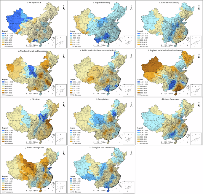
a Spatial regression coefficient of GDP per capita factor. b Spatial regression coefficient of population density factor. c Spatial regression coefficient of road network density factor. d Spatial regression coefficient of number of hotels and homestays factor. e Spatial regression coefficient of perfection of public service factor. f Spatial regression coefficient of number of cultural institutions factor. g Spatial regression coefficient of elevation factor. h Spatial regression coefficient of precipitation factor. i Spatial regression coefficient of distance from water factor. j Spatial regression coefficient of forest coverage rate factor. k Spatial regression coefficient of ecological land connectivity factor.
(1) Economic development level factor. As can be seen from Fig. 8a, the direction and intensity of economic factors’ influence on the spatial coupling coordination level of RHH and RTV show obvious spatial differences, that is, economic factors mainly show negative influence in northwest China, North China Plain, middle reaches of the Yangtze River, Pearl River Delta region and Beibu Gulf region. While in other regions, it is positive (the per capita GDP and spatial coupling coordination level are both high, or the per capita GDP and spatial coupling coordination level are both low). In the North China Plain, there are more RHH and RTV, and the coupling coordination level between the two is high, but the per capita GDP is low, so the economic factors have a negative impact.
(2) Population density factor. As can be seen from Fig. 8b, the direction and intensity of influence of population density on the spatial coupling coordination level of RHH and RTV show obvious spatial differences. On the other hand, eastern Qinghai, central Gansu, Ningxia Plains and Yunnan-Guizhou Plateau have low population densities, and the number of RHH and RTV is large, and the coupling coordination level between the two is high. Therefore, population factors have a significant negative impact on the spatial coupling coordination level between RHH and RTV.
(3) Rural tourism infrastructure factors. As can be seen from Fig. 8c, road network density factors show significant spatial differences in the direction and intensity of influence on the spatial coupling coordination level of RHH and RTV. Among them, in the Beijing-Tianjin-Hebei urban cluster and the Yangtze River Delta urban cluster in China, the road network density factor shows a weak negative impact, mainly because the road network in the region is dense and the traffic is developed, while the spatial coupling coordination level of RHH and RTV is relatively low. In the North China Plain and Central China, which are the first terrains in China, traffic is relatively developed and there are relatively many RHH and RTV. Therefore, the road network density factor has a positive impact on the spatial coupling coordination level between RHH and RTV. In the topographic transition zone of China’s second topographic ladder (Taihang Mountain area, Western Henan Mountain area, Qinling Mountain area, Daba Mountain area, Yunnan-Guizhou Plateau), the traffic is not developed, but there are relatively more rural habitat heritage and rural tourism key villages, so the road network density factor shows a strong negative impact. As can be seen from Fig. 8d, the number of hotels and homestay factors mainly have a positive impact on the spatial coupling coordination level of RHH and RTV, indicating that rural tourism infrastructure plays an important positive role in promoting the spatial coupling coordination level between RHH and RTV. A few regions (western Inner Mongolia, Gansu Province, eastern Qinghai Province, Hainan Province and Pearl River Delta urban cluster) have a negative impact. The reason is that western Inner Mongolia, Gansu, eastern Qinghai and Hainan Provinces are densely populated areas with beautiful natural environment and numerous rural cultural heritage and historical sites. Rural ecotourism and cultural tourism are favored and sought after by residents of the central and eastern regions. Therefore, the spatial coupling and coordination level between RHH and RTV is high. However, at the same time, the rural tourism infrastructure is not perfect due to the low level of economic development in this region, so the rural tourism infrastructure has a negative impact on the spatial coupling coordination level between RHH and RTV.
(4) Public service facilities. As can be seen from Fig. 8e, the spatial distribution characteristics of the local regression coefficient of the public service facilities factor are basically the same as that of the number of hotels and homestays, that is, it has a positive impact on most regions of China, indicating that public service facilities have an important positive promoting effect on the spatial coupling coordination level between RHH and RTV. The public service facilities factor has a negative effect on a few regions (Greater Khinganling Region, Western Henan Mountain area, western Sichuan Plateau, Dabbe Mountain Area, Hainan Province, Beijing-Tianjin-Hebei city cluster, Pearl River Delta city cluster). Among them, the Greater Khinganling region, the Western Henan Mountain region, the western Sichuan Plateau, the Dabbe Mountain region, and Hainan Province are all located in mountainous areas, where the level of economic development is low and public financial expenditure is low, so public services are less available. However, such areas have beautiful natural environment and numerous rural cultural heritage and agricultural heritage. Rural ecotourism and cultural tourism are favored and sought after by most tourists. Therefore, the factors of public service facilities have a negatively impact on the spatial coupling and coordination level of RHH and RTV. The public service facilities in the economically developed regions such as Beijing-Tianjin-Hebei urban cluster and Pearl River Delta urban cluster are relatively perfect, and the low rural cultural heritage endowment is the main reason that the public service facilities factors have a negative impact on the spatial coupling coordination level between RHH and RTV in the region.
(5) Cultural environment factor. As can be seen from Fig. 8f, the direction and intensity of influence of cultural environment factors on the spatial coupling coordination level of RHH and RTV show obvious spatial differences. In western Henan Province, Dabie Mountain area, Dabie Mountain area, western Sichuan Plateau, Yunnan-Guizhou Plateau, and northern mountain area of Hebei Province, the number of rural cultural heritage in these areas has a certain scale (Fig. 1c). At the same time, due to the good rural ecological environment and rich ecological tourism resources in these areas, rural tourism has developed rapidly (Fig. 1d). Therefore, the spatial coupling coordination level of RHH and RTV is relatively high in these regions (Fig. 5). However, due to the low level of economic development, the government’s financial and social capital investment in cultural institutions is slightly insufficient, resulting in a small number of cultural institutions. Therefore, cultural environment factors have a weak negative impact on the spatial coupling coordination level of RHH and RTV. It can be inspired that promoting the construction of cultural institutions and the construction of cultural environment is the key to the protection of rural cultural heritage and the high-quality development of rural tourism in the central and western mountainous areas and the transition zone of between mountain and plain in the future. The Chongqing city, Central Guizhou urban agglomeration and Poyang Lake urban circle have higher investment in cultural construction and better social and cultural environment, but the low endowment of rural cultural heritage is the main reason for the negative impact of cultural environment factors on the spatial coupling level between RHH and RTV in the region.
(6) Topographic factors. As can be seen from Fig. 8g that topographic factors mainly have a positive impact on the spatial coupling coordination level of RHH and RTV in China, indicating that the spatial coupling coordination level of RHH and RTV is higher in mountainous areas with higher terrain. However, in high-altitude areas such as the Qinghai Plateau, Tianshan Mountain Range, Inner Mongolia Plateau, western Sichuan Plateau and Yunnan-Guizhou Plateau, the ecological environment is harsh and human production and living conditions are poor, resulting in less rural cultural heritage and lagging rural tourism development. Therefore, topographic factors mainly have a negative impact on the spatial coupling coordination level of RHH and RTV in China.
(7) Precipitation factor. As can be seen from Fig. 8h, the precipitation factor mainly has a positive impact on the spatial coupling coordination level of RHH and RTV in China, indicating that the spatial coupling coordination level of RHH and RTV is higher in regions with higher precipitation. The precipitation in central and western regions of China, such as Qinghai Plateau, western Inner Mongolia Plateau, Gansu Province, Ningxia Province, northern Shaanxi Province, Henan Province and central and western Shandong Province, is relatively low, but there are more rural cultural heritage, agricultural heritage and historical and cultural monuments left behind by historical factors.
(8) Water system factors. As can be seen from Fig. 8i, water system factors mainly have a positive influence on the spatial coupling coordination level of RHH and RTV in China, and the positive influence areas are mainly distributed in northeast China, the Yellow River basin and the Yangtze River basin. The negative influence areas are mainly distributed in Xinjiang Autonomous Region, Tibet Autonomous Region, western Qinghai Province, northwestern Gansu Province, desert region of Central Inner Mongolia, and northern Shanxi and Shaanxi. These regions have relatively dry climate, few surface water systems, few rural cultural heritage, and lagging rural tourism development.
(9) Eco-environmental factors. As can be seen from Fig. 8j, the forest coverage factor mainly has a positive impact on the spatial coupling coordination level of RHH and RTV in China, indicating that forest coverage has an important positive promoting effect on the spatial coupling coordination level of RHH and RTV. The eastern Taihang Mountains, the eastern Shandong Peninsula, the eastern coastal areas of Jiangsu, the Dalliang Mountains, and the Wumeng Mountains are negatively impact areas, because the forest coverage rate in this region is high, but the spatial coupling coordination level of RHH and RTV lags behind the forest coverage rate. As can be seen from Fig. 8k, ecological land connectivity factors also have a mainly positive impact on the spatial coupling coordination level of RHH and RTV in China, indicating that ecological land connectivity has an important positive promoting effect on the spatial coupling level between RHH and RTV. The plateau areas in southwest China, the ethnic minority populated areas in northwest China, the middle reaches of the Yangtze River, the hilly areas of Guangxi and Guangzhou, and the forest areas in Northeast China. There are a number of rural cultural heritage and historical sites in the South West Plateau region and in ethnic minority areas in the North West. Rural ecotourism and cultural tourism are favored and sought after by the residents in the central and eastern regions. However, due to the influence of climate factors, the ecological land connectivity is poor, and thus the spatial coupling coordination level of RHH and RTV in this region is negatively affected by ecological land connectivity. The climate in the middle reaches of the Yangtze River, the hilly areas of Liangguang and the forested areas of Northeast China is humid and the ecological land connectivity is good, but the rural cultural heritage is relatively small and the development of rural tourism is slow. Therefore, ecological land connectivity also negatively affects the spatial coupling coordination level of RHH and RTV in this region.
Interactive effect of natural environment and socioeconomic factors
Further, we use the OPGD model to analyze the interaction effect of superposition between factors on the spatial coupling level between RHH and RTV. Specifically, the OPGD package of R4.2.3 software is used to analyze the OPGD model. The analysis process is as follows: First, the Factor detector module of the OPGD model is used to check the significance level of the factors. Then, the Interaction detector module is used to analyze the interaction effects of the superposition between factors on the spatial coupling of RHH and RTV.
The analysis results of factor detector show that (Table 6), the P-values of economic factor (X1), population factor (X2), rural tourism facility condition factor (X3 and X4), rural public service facility condition factor (X5), social and cultural environment factor (X6), terrain factor (X7), climate factor (X8), water system factor (X9) and ecological environment factor (X10 and X11) all passed the significance test. It shows that the economy, population, conditions of rural tourism facilities, conditions of rural public service facilities, social and cultural environment, terrain, water system, climate, and ecological environment all have significant impact on the spatial coupling between RHH and RTV.
The analysis results of interactive detector show that (Fig. 9), the superposition of the two factors has a significant interaction influencing on the spatial coupling relationship between RHH and RTV. Specifically: (1) From the interaction effect of socio-economic factors (Fig. 9), the interaction of five factors, including economic, population, conditions of rural tourism facilities, conditions of rural public service facilities, and regional social and cultural environment, has a significant interactive impact on the spatial coupling relationship between RHH and RTV. Among them, the interaction between economic factor and rural public service facility condition factor and regional social and cultural environment factor is strong, and the interaction between population factor and rural public service facility condition factor and regional social and cultural environment factor is also strong, both of which are manifested as Enhance, nonlinear. (2) From the interaction effect of natural environment factors (Fig. 9), the interaction of topographic, climatic, hydrology, and eco-environment factors has a significant interactive impact on the spatial coupling relationship between RHH and RTV. Among them, the interaction between terrain and precipitation factors has a strong interaction effect on the spatial coupling relationship between RHH and RTV, and the interaction between precipitation factors, water system factors and ecological land connectivity factors has a strong interaction effect on the spatial coupling relationship between RHH and RTV. It can reflect the higher spatial coupling coordination level of RHH and RTV in mountainous areas with higher altitude, humid climate and better ecological environment. (3) From the interaction effect between natural environment factors and socio-economic factors, the interaction between natural factors and socio-economic factors has a significant interaction impact on the spatial coupling relationship between RHH and RTV.

Interaction effect of natural environment and socio-economic factors on the spatial coupling between RHH and RTV.
Influencing mechanism of natural environment and socioeconomic factors
Based on the above analysis results of OLS, GWR and OPGD models (Sections 3.2.1 to 3.2.3), we systematically summarized the influencing mechanism of natural environment and socio-economic factors on the spatial coupling level between RHH and RTV, and plotted the influencing mechanism diagram of natural environment and socio-economic factors (Fig. 10). The specific influencing mechanism of the factors are analyzed as follows.

Influencing mechanism of natural environment and socio-economic factors on the spatial coupling level between RHH and RTV.
From the perspective of the influence mechanism of socioeconomic factors: (1) Economic development level and population factors are the fundamental driving factors that affect the spatial coupling between RHH and RTV. Production and living conditions and population agglomeration can form good economic conditions for rural settlements, and the improvement of economic conditions can change people’s production and living styles and spiritual and cultural needs, enhance rural residents’ pursuit of cultural and spiritual life, and promote the generation of rural residential heritage and cultural tourism resources (Fig. 10). At the same time, the improvement of the overall regional economic development level can also increase the attention and cognition of urban and rural residents to rural residential heritage and rural tourism, and then realize the integration of resources and elements between rural residential heritage and tourism villages by providing a more efficient market transaction system. Rural human settlement heritage provides cultural tourism resources and gives cultural connotations to the tourism development of rural settlements, and key tourism villages in turn provide important spatial carriers for RHH and promote its protection and activation. As a result, RHH and RTV have formed a highly coupled state of mutual promotion and improvement. (2) Rural tourism facilities and rural public service facilities are important external driving forces for the coupling development of RHH and RTV. The construction and improvement of rural tourism facilities, such as resort hotels, homestays, catering and retail facilities, can attract more tourists to visit, and then promote the development of tourism village economy (Fig. 9). The construction of these facilities is often combined with the protection and development of RHH and RTV, which can promote the development of rural tourism industry in key tourism villages, and the improvement of tourism income can indirectly promote the protection and inheritance of rural residential heritage, so as to achieve a win-win situation of economic and cultural benefits. Rural public service facilities are another important driving force affecting the development of rural residential heritage, key tourism villages and their coupling. The improvement of rural public service facilities, such as transportation, communication, water, electricity and medical facilities, provides better infrastructure support for rural communities, can improve the overall image and quality of life of rural areas, attract more investment and talent flow to rural areas, and then promote the protection and activation of rural residential heritage and the development of cultural tourism resources. At the same time, improvements of rural public service facilities provide better infrastructure support for the development of rural tourism in rural settlements, promote tourist satisfaction and loyalty, and make the protection and development of rural residential heritage and key tourist villages more sustainable. (3) Sociocultural environmental factors are the important internal driving forces for the coupling development of RHH and RTV. From the perspective of the history, times and particularities of rural cultural development, first of all, the heritage of rural settlements carries rich historical memories and cultural traditions, and is not only a symbol of rural culture, but also an important witness of rural historical development. Socio-cultural environmental factors, such as historical traditions, religious beliefs and social values, combine to shape the unique features of rural residential heritage, making it an important resource for attracting tourists. Second, with the continuous development of society, rural culture is also constantly evolving, and new social and cultural elements are constantly integrated into the countryside, injecting new vitality into the rural residential heritage and key tourist villages. For example, the popularization of modern tourism concepts has promoted the development of rural tourism, making rural residential heritage and key tourist villages become popular tourist destinations. Finally, villages have their own unique cultural characteristics and historical background, which makes the RHH and RTV have distinct regional characteristics. Social and cultural environment factors play a key role in shaping the particularity of rural areas. For example, rural human settlement heritage with unique cultural elements such as folk customs and traditional culture, as well as other rural tourism resources have become an important attraction for rural tourism, promoting the coupling development of RHH and RTV. (4) In addition, through the analysis of the driving mechanism of the above factors, it can be found that economic, population, rural tourism facilities, rural public service facilities, and social and cultural environment factors often do not act independently in the process of affecting the rural residential heritage, key tourism villages and their spatial coupling relationship, but there is a complex and synergistic effect. Jointly drive the formation and development of rural human settlement heritage, key rural tourism villages, and their coupling relationship.
From the perspective of the influence mechanism of natural factors and between natural environment and socioeconomic factors, different surface forms, climatic conditions and ecological environment conditions can form different natural textures and spatial organizations (Fig. 10). Suitable climatic conditions, sufficient water sources (water system factors) and ecological environment conditions can form more suitable conditions for rural settlement construction and production and living conditions. It brings about agricultural development, economic development and population clustering in rural areas, promotes the production of cultural heritage and cultural tourism resources, and ultimately affects the protection and activation of rural human-settlement heritage (RHH) and the development and layout of key tourist villages. In the mountainous areas of central and eastern China, where the climate is suitable, relatively closed and isolated geographical space are easily formed, allowing villages to form self-sufficient natural economies and distinctive folk customs. In the process of the evolution of human-land relations, the birth, succession and development of regional culture and RHH have been promoted, and traditional villages have been preserved. Make it suitable and stable for inheritance and protection of RHH. At the same time, the mountainous counties with more suitable climate in central and eastern China have a large number of mountain villages with their own characteristics, which have a large number of natural tourism resources and beautiful ecological environment, and have the suitability and stability of the development of key tourist villages. As a result, terrain, climate conditions, water systems and high-quality ecological environment can interact and jointly promote the development of RHH and RTV in a highly coupled state.
Discussion
The contributions of this research are mainly reflected in three aspects: (1) Based on the existing research results, this paper proposed a theoretical framework for the driving mechanism of the spatial coupling relationship between RHH and RTV, which enriches the relevant theoretical research of the spatial coupling mechanism between RHH and RTV. (2) Based on the county scale, we calculate the spatial coupling level of RHH and RTV in China and discuss the spatial differentiation rule,which enriches the relevant research results. (3) Based on the perspective of geographical space, this study selected and quantified natural environment factors and socioeconomic factors, and then comprehensively analyzed the influencing mechanism of natural environment and socioeconomic factors on the spatial coupling level of RHH and RTV in China by using OLS, GWR and OPGD model. Compared with micro-studies and case studies, from the perspective of geographical space, spatial analysis methods and econometric models can be used to systematically and quickly analyze the global and local influencing factors of the spatial coupling coordination level of RHH and RTV in China. The research results can further provide theoretical reference and data support for decision makers and managers in the process of formulating coordinated development policies of RHH and RTV in China and various regions at the macro level. However, due to the limited time and funds, micro research and case studies based on field research can only carry out typical case studies in a small area, and the research results are obviously lack of systematic and overall significance for decision-makers at the national level.
However, there are still some limitations and deficiencies in this study. First of all, due to the difficulty in obtaining the index data of influencing factors for the spatial coupling coordination level of RHH and RTV at the county scale in China, this study selected and quantified 9 factors (11 influencing factor indicators), including economy, population, conditions of rural tourism facilities, conditions of rural public service facilities, social and cultural environment, terrain, climate, water system and ecological environment. In addition, policy factors (heritage development and protection policy and rural tourism policy) and other factors are also important factors affecting the spatial coupling of RHH and RTV, but their data are difficult to obtain temporarily. Therefore, the indicator system of influencing factors proposed in this study still needs to be further improved. In the future, more influencing factor indicators can be quantified by remote sensing technology, big data technology and questionnaire, so as to improve the influencing factor indicator system. Second, the index data of some influencing factors lack historical data, such as the vector data of highway network and water system before 2022, and the spatial point data of hotel homestays, public service facilities and cultural institutions before 2018. Therefore, this study does not use panel data, but uses cross-sectional data (2022) to carry out research, which is another shortcoming of this paper. Third, this study attempts to systematically summarize the interaction mechanism between natural environment and socio-economic factors on the spatial coupling level of RHH and RTV. However, due to the complexity of the interaction mechanism itself, the influencing mechanism proposed in this study is not perfect. Therefore, the interaction mechanism of natural environment and socio-economic factors on the spatial coupling level between RHH and RTV is still the focus and difficulty for future research.
Conclusions
In this study, bivariate spatial autocorrelation model and spatial coupling coordination model were used to quantitatively analyze the spatial coupling level between RHH and RTV at the county scale in China. Then, OLS, GWR and OPGD model were used to analyze the linear influencing, spatial heterogeneous effect and interactive effect of natural environment and socioeconomic factors on the spatial coupling level between RHH and RTV, and systematically summarized the influencing mechanism of natural environment and socioeconomic factors. The main conclusions are as follows:
-
(1)
The spatial coupling coordination level between RHH and RTV in China show significant east-west differentiation. Severe and moderate discordant areas are mainly distributed in Northeast China, arid and semi-arid areas in Western China, plateau areas in Southwest China, densely populated urban agglomerations in central and eastern China, and plain agricultural areas. Mild discoordination areas and basic and moderate coordination areas are mainly distributed in areas inhabited by ethnic minorities with rich rural human-settlements heritage and relatively complete rural tourism industries, transition zones in mountainous and plain areas, economically developed mountainous and hilly counties along the southeastern coast, and coastal tourist cities.
-
(2)
Influencing factors such as economy, population, conditions of rural tourism facilities, conditions of rural public service facilities, sociocultural environment, terrain, climate, and ecological environment all have significant impact on the spatial coupling level between RHH and RTV.
-
(3)
In terms of the spatial heterogeneous effect of influencing factors, economy, population, conditions of rural tourism facilities, conditions of rural public service facilities, sociocultural environment, terrain, climate, and ecological environment factors show obvious spatial differences on the direction and intensity of impact on the spatial coupling level between RHH and RTV. In terms of the interaction effects of influencing factors, the interaction between natural environment and socioeconomic factors has a significant interactive effect on the spatial coupling level between RHH and RTV.
-
(4)
Economic development level and population factors are the fundamental factors that affect the spatial coupling between RHH and RTV. Rural tourism facilities and rural public service facilities are important external driving forces for the coupling development of RHH and RTV. Sociocultural environmental factors are the important internal driving forces for the coupling development of RHH and RTV. Different surface forms, different climate conditions and different ecological environment conditions can form different natural textures and spatial organizations. Suitable climate conditions, sufficient water sources and ecological environment conditions can form more suitable rural settlement construction conditions and production and living conditions, and ultimately affect the protection and activation of rural human settlement heritage and the development and layout of key tourist villages. The spatial coupling relationship between RHH and RTV is the result of the complex interaction between the natural directivity law caused by natural environmental factors and the humanistic directivity law caused by human social and economic activities.


Responses